
IMAGES TAKEN NEAR TO
Palmera Avenue, READING, RG31 7DZ
Introduction
This page details the photographs taken nearby to Palmera Avenue, RG31 7DZ by members of the Geograph project.
The Geograph project started in 2005 with the aim of publishing, organising and preserving representative images for every square kilometre of Great Britain, Ireland and the Isle of Man.

There are currently over 7.5m images from over14,400 individuals and you can help contribute to the project by visiting https://www.geograph.org.uk
Image Map
Images are licensed for reuse under creativecommons.org/licenses/by-sa/2.0
Notes
- Clicking on the map will re-center to the selected point.
- The higher the marker number, the further away the image location is from the centre of the postcode.
Image Listing (26 Images Found)
Images are licensed for reuse under creativecommons.org/licenses/by-sa/2.0
Image
Details
Distance
1
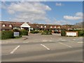
Calcot Hotel: A4
The hotel is situated at the intersection of the A4 and the Calcot estate road. It is in the north eastern section of the square.
Image: © Pam Brophy
Taken: 10 Apr 2005
0.07 miles
2
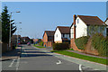
Pollard's Way, Holybrook
The road connects Calcot's Beansheaf and Ford's Farm estates. At this point there's a restriction in place, meaning that only buses may proceed into The Chase (behind the photographer).
Image: © Andrew Smith
Taken: 4 Mar 2011
0.09 miles
3

Charrington Road, Calcot
At the junction with the rustically named Willow Tree Glade.
The bus is on route 26, the yellow route on Reading's colour coded bus system.
Image: © Des Blenkinsopp
Taken: 4 Nov 2013
0.14 miles
4
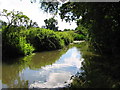
The Holy Brook, Calcot
A view of the Holy Brook in the woodland/parkland/flood plains to the south of Calcot
Image: © Chris Collard
Taken: 3 Aug 2005
0.16 miles
5

Holy Brook
A lengthy backwater of the River Kennet which leaves it at Theale and rejoins in Reading.
Image: © Robin Webster
Taken: 25 Oct 2015
0.16 miles

7

Footbridge over Holy Brook
Not a designated public footpath, but part of the large area of public open space here.
Image: © Robin Webster
Taken: 25 Oct 2015
0.17 miles
8

Bath Road before the junction of Charrington Road
Image: © David Howard
Taken: 6 Mar 2016
0.18 miles
9

Bath Road, Calcot
The fence has appeared since 2012. Maybe too many people were escaping.
Image: © David Howard
Taken: 6 Mar 2016
0.18 miles
