IMAGES TAKEN NEAR TO
Dee Road, READING, RG30 4AT
Introduction
This page details the photographs taken nearby to Dee Road, RG30 4AT by members of the Geograph project.
The Geograph project started in 2005 with the aim of publishing, organising and preserving representative images for every square kilometre of Great Britain, Ireland and the Isle of Man.

There are currently over 7.5m images from over14,400 individuals and you can help contribute to the project by visiting https://www.geograph.org.uk
Image Map
Images are licensed for reuse under creativecommons.org/licenses/by-sa/2.0
Notes
- Clicking on the map will re-center to the selected point.
- The higher the marker number, the further away the image location is from the centre of the postcode.
Image Listing (26 Images Found)
Images are licensed for reuse under creativecommons.org/licenses/by-sa/2.0
Image
Details
Distance
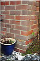
1
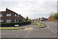
#26 Dee Road at junction with Tern Close
On the corner of the house is an OS benchmark Image
Image: © Roger Templeman
Taken: 24 Oct 2011
0.00 miles
2
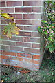
Benchmark on #26 Dee Road (Tern Close face)
Ordnance Survey cut mark benchmark described on the Bench Mark Database at http://www.bench-marks.org.uk/bm39881
Image: © Roger Templeman
Taken: 24 Oct 2011
0.00 miles
3
Elvaston Way, Reading
The junction with Poole Close is in the foreground.
Image: © Andrew Smith
Taken: 2 Mar 2010
0.09 miles
4
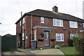
Numbers 7,9 and 15 Dee Road
There is an OS benchmark Image by the flower pot at the left side of the house
Image: © Roger Templeman
Taken: 4 Nov 2011
0.12 miles
5
Benchmark above the side path to #7 Dee Road
Ordnance Survey cut mark benchmark described on the Bench Mark Database at http://www.bench-marks.org.uk/bm40002
Image: © Roger Templeman
Taken: 4 Nov 2011
0.12 miles
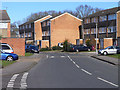
6
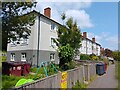
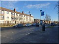
70-92 The Meadway
70-92 The Meadway is a block of flats on The Meadway, raised above the road level.
Image: © Oscar Taylor
Taken: 16 May 2023
0.14 miles
7
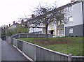
Flats on The Meadway
There are a number of blocks of these social house (council) flats along The Meadway, built in the 1960's as Reading expanded rapidly to the west. Attempts have been made recently to make them more attractive with coloured blocks of paintwork but if anything they now look more austere and quite threatening being raised a little bit above the road.
Image: © Graham Horn
Taken: 10 Nov 2007
0.17 miles
8
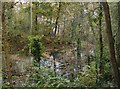
Pond in Lousehill Copse
Lousehill Copse is a band of green between two areas of poorer estate housing to the west of Reading. The local community takes pride in the Copse and has regular tidy-ups and events.
Image: © Graham Horn
Taken: 10 Nov 2007
0.17 miles
9
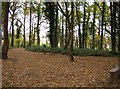
Lousehill Copse
A band of green within the Reading estates is well used by the local community and offers very pleasant woodland walks just a few minutes from many homes.
Image: © Graham Horn
Taken: 10 Nov 2007
0.18 miles
10
Dryland House, The Meadway
A block of flats on The Meadway, and bus stop.
Image: © Oscar Taylor
Taken: 19 Jan 2023
0.19 miles