IMAGES TAKEN NEAR TO
RG30 3RP
Introduction
This page details the photographs taken nearby to RG30 3RP by members of the Geograph project.
The Geograph project started in 2005 with the aim of publishing, organising and preserving representative images for every square kilometre of Great Britain, Ireland and the Isle of Man.

There are currently over 7.5m images from over14,400 individuals and you can help contribute to the project by visiting https://www.geograph.org.uk
Image Map
Images are licensed for reuse under creativecommons.org/licenses/by-sa/2.0
Notes
- Clicking on the map will re-center to the selected point.
- The higher the marker number, the further away the image location is from the centre of the postcode.
Image Listing (8 Images Found)
Images are licensed for reuse under creativecommons.org/licenses/by-sa/2.0
Image
Details
Distance
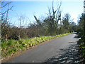
1
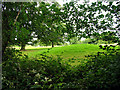
A Glimpse of Wokefield Golf Course
The golf course extends from the adjacent square in the south, into the southern end of this square. The golf course is part of the Wokefield Park Conference Centre. This view was taken east of the minor road, in the south western corner of the square.
Image: © Pam Brophy
Taken: 4 Jul 2005
0.00 miles
2
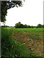
Cornfield in Wokefield
This square is difficult to access on foot as there are no footpaths and very few safe places to stop/park. There are minor roads but the hedgerows are so tall this time of the year it's difficult to see the land behind them! The square is mostly farmland.
Image: © Pam Brophy
Taken: 4 Jul 2005
0.00 miles
4
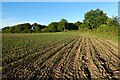
Farmland, Wokefield
A crop of maize to the west of Pitchkettle Wood.
Image: © Andrew Smith
Taken: 14 Jun 2022
0.14 miles
6
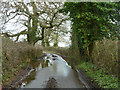
Puddles on New Road
Not a route for a double-decker bus.
Image: © Robin Webster
Taken: 6 Mar 2014
0.20 miles
7
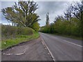
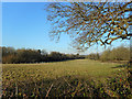
Lay-by on Goring Lane
A lay-by on Goring Lane, looking towards Grazeley Green.
Image: © Oscar Taylor
Taken: 23 Apr 2023
0.24 miles
8
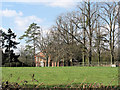
Oakfield
This is a very interesting house because it has English Heritage Building ID: 40035 but is in the rare category DL. This stands for delisted and a short explanation is halfway down page: http://www.britishlistedbuildings.co.uk/site/about-listed-buildings/
The original building dates from the 18th C and was restored during the 19th and 20th C.
Image: © Stuart Logan
Taken: 14 Mar 2013
0.24 miles