
IMAGES TAKEN NEAR TO
Buckthorn Road, WHITCHURCH, RG28 7FZ
Introduction
This page details the photographs taken nearby to Buckthorn Road, RG28 7FZ by members of the Geograph project.
The Geograph project started in 2005 with the aim of publishing, organising and preserving representative images for every square kilometre of Great Britain, Ireland and the Isle of Man.

There are currently over 7.5m images from over14,400 individuals and you can help contribute to the project by visiting https://www.geograph.org.uk
Image Map
Images are licensed for reuse under creativecommons.org/licenses/by-sa/2.0
Notes
- Clicking on the map will re-center to the selected point.
- The higher the marker number, the further away the image location is from the centre of the postcode.
Image Listing (136 Images Found)
Images are licensed for reuse under creativecommons.org/licenses/by-sa/2.0
Image
Details
Distance
1

Whitchurch, Park View
A recently built street off Wells's Lane on the western edge of Whitchurch.
Image: © Des Blenkinsopp
Taken: 5 Oct 2016
0.07 miles
2

Building site, Whitchurch
A greenfield site, which had the footpath diverted to the right going diagonally across it.
Image: © Robin Webster
Taken: 13 Feb 2017
0.08 miles
3

Fallen trees near Manor Farm
As the footpath heads towards the A34 passing Manor Farm there a number of fallen trees.
Image: © Maigheach-gheal
Taken: 12 Jul 2008
0.09 miles
4

Foot subway under old railway, Whitchurch
This passes under the course of the Didcot, Newbury and Southampton line just north of the site of the station here. Looking at old maps, it was a way to the northbound platform, avoiding crossing the tracks on the level, as well as a footpath route, which it still is.
Image: © Robin Webster
Taken: 13 Feb 2017
0.10 miles
5

Whitchurch Town railway station (site), Hampshire
Opened in 1885 by the Didcot, Newbury & Southampton Railway, this station closed to passengers in 1960 and completely in 1963.
View south towards Sutton Scotney and Southampton.
Image: © Nigel Thompson
Taken: 1 Apr 2001
0.10 miles
6
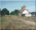
Remains of Whitchurch Town Station, Hants
Situated in Wells Lane, this station was one of several on the Didcot, Newbury and Southampton Railway which opened on the 1st January 1891. It closed to passengers in March 1960, together with the section South of Newbury. Goods traffic on that section finished in August 1964 and the track was subsequently lifted in 1967. Its postcode is RG28 7AU.
Image: © David Hillas
Taken: 15 Sep 1979
0.11 miles

8

Park View, Whitchurch
A recently built street off Wells's Lane on the western edge of Whitchurch.
Image: © Des Blenkinsopp
Taken: 5 Oct 2016
0.11 miles
9

Bloswood Lane, Whitchurch
From under the disused railway bridge.
Image: © JThomas
Taken: 26 Apr 2022
0.13 miles
10

Former railway bridge
This bridge carries the former Didcot, Newbury, Southampton railway line over Bell Street on the western side of the town.
Image: © Graham Horn
Taken: 12 Jul 2008
0.13 miles