IMAGES TAKEN NEAR TO
Church Lane, BASINGSTOKE, RG25 2EN
Introduction
This page details the photographs taken nearby to Church Lane, RG25 2EN by members of the Geograph project.
The Geograph project started in 2005 with the aim of publishing, organising and preserving representative images for every square kilometre of Great Britain, Ireland and the Isle of Man.

There are currently over 7.5m images from over14,400 individuals and you can help contribute to the project by visiting https://www.geograph.org.uk
Image Map
Images are licensed for reuse under creativecommons.org/licenses/by-sa/2.0
Notes
- Clicking on the map will re-center to the selected point.
- The higher the marker number, the further away the image location is from the centre of the postcode.
Image Listing (90 Images Found)
Images are licensed for reuse under creativecommons.org/licenses/by-sa/2.0
Image
Details
Distance
1
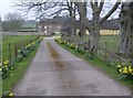
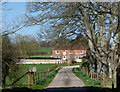
Manor Farm
The driveway to Manor Farm from near the chapel.
Image: © Graham Horn
Taken: 24 Mar 2007
0.02 miles
3
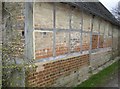
Brickie required (again)
This wall has had a few patches and mends in its time.
Image: © Graham Horn
Taken: 24 Mar 2007
0.10 miles
4
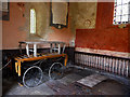
Preston Candover - Old Church of St Mary the Virgin
Image: © Colin Park
Taken: 7 Apr 2018
0.10 miles
5
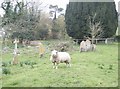
Surprised sheep
"Not me gov, I don't even like daffodil heads, I only go for the grass".
In the churchyard of the Old Chancel of St. Mary the Virgin, Preston Candover
Image: © Graham Horn
Taken: 24 Mar 2007
0.11 miles
6
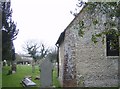
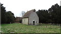
The Old Chancel of St. Mary the Virgin (from east)
See information here Image]
Image: © Graham Horn
Taken: 24 Mar 2007
0.11 miles
7
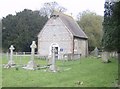
The Old Chancel of St. Mary the Virgin (from west)
See information here Image]
Image: © Graham Horn
Taken: 24 Mar 2007
0.11 miles
8
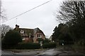
House on Alresford Road, Preston Candover
Image: © David Howard
Taken: 15 Dec 2018
0.12 miles
10
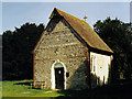
St Mary Old Church, Preston Candover
Grade 2* listed building erected in the 12th century. Destroyed by fire in 1884. Only the chancel remains.
Image: © Michael FORD
Taken: Unknown
0.12 miles