IMAGES TAKEN NEAR TO
Sheepwash Court, BASINGSTOKE, RG24 9GW
Introduction
This page details the photographs taken nearby to Sheepwash Court, RG24 9GW by members of the Geograph project.
The Geograph project started in 2005 with the aim of publishing, organising and preserving representative images for every square kilometre of Great Britain, Ireland and the Isle of Man.

There are currently over 7.5m images from over14,400 individuals and you can help contribute to the project by visiting https://www.geograph.org.uk
Image Map
Images are licensed for reuse under creativecommons.org/licenses/by-sa/2.0
Notes
- Clicking on the map will re-center to the selected point.
- The higher the marker number, the further away the image location is from the centre of the postcode.
Image Listing (218 Images Found)
Images are licensed for reuse under creativecommons.org/licenses/by-sa/2.0
Image
Details
Distance
1
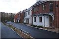
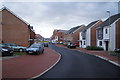
New housing by 'The Spinney'
The road did not yet have a name but the houses back onto Highpath Way.
Image: © Fernweh
Taken: 13 Jan 2014
0.01 miles
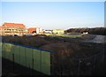
2
Temporary fence
A patch of woodland is saved from the encroaching housing development.
Image: © Mr Ignavy
Taken: 6 Mar 2009
0.03 miles
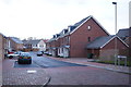
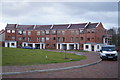
4
Last of the new housing
The final homes are being built on the former farmland west of North Hants Hospital. Quite a large development has taken place here since 2008.
Image: © Fernweh
Taken: 13 Jan 2014
0.03 miles
6
Edge of 'The Spinney'
From now on it's new housing on former farmland.
Image: © Fernweh
Taken: 13 Jan 2014
0.04 miles
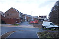
7
Applying the finishing touches
New development west of the hospital. Road had no visible name when this was taken.
Image: © Fernweh
Taken: 13 Jan 2014
0.05 miles
8
Housing in a round
Off Highpath Way. Not sure what their address will be, no new road signs visible.
Image: © Fernweh
Taken: 13 Jan 2014
0.05 miles
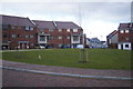
9
Limes Park development
The trees in the middle distance are known locally as The Spinney.
Image: © Mr Ignavy
Taken: 24 Jan 2009
0.07 miles
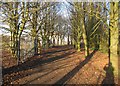
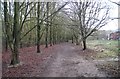
10
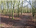
Footpath in woodlands
A small patch of woodland just to the north of the Newbury Road roundabout on the A33.
Image: © Mr Ignavy
Taken: 12 Jan 2008
0.07 miles