IMAGES TAKEN NEAR TO
RG22 5TD
Introduction
This page details the photographs taken nearby to RG22 5TD by members of the Geograph project.
The Geograph project started in 2005 with the aim of publishing, organising and preserving representative images for every square kilometre of Great Britain, Ireland and the Isle of Man.

There are currently over 7.5m images from over14,400 individuals and you can help contribute to the project by visiting https://www.geograph.org.uk
Image Map
Images are licensed for reuse under creativecommons.org/licenses/by-sa/2.0
Notes
- Clicking on the map will re-center to the selected point.
- The higher the marker number, the further away the image location is from the centre of the postcode.
Image Listing (561 Images Found)
Images are licensed for reuse under creativecommons.org/licenses/by-sa/2.0
Image
Details
Distance
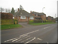
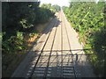
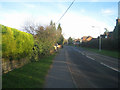
3
Oakley Lane
Just after passing under the railway bridge.
Image: © Fernweh
Taken: 11 Oct 2014
0.01 miles
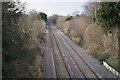
7
Main line towards Salisbury
Viewed from St John's Road bridge.
Image: © Fernweh
Taken: 9 Oct 2017
0.02 miles
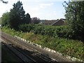
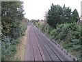
9
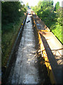
No railway for now
The track is being lowered under the road bridges to allow the larger 9'6" containers to be carried on standard freight wagons via Andover and Romsey.
Image: © Mr Ignavy
Taken: 1 Oct 2011
0.03 miles