
IMAGES TAKEN NEAR TO
Horris Hill, NEWBURY, RG20 9DT
Introduction
This page details the photographs taken nearby to Horris Hill, RG20 9DT by members of the Geograph project.
The Geograph project started in 2005 with the aim of publishing, organising and preserving representative images for every square kilometre of Great Britain, Ireland and the Isle of Man.

There are currently over 7.5m images from over14,400 individuals and you can help contribute to the project by visiting https://www.geograph.org.uk
Image Map
Images are licensed for reuse under creativecommons.org/licenses/by-sa/2.0
Notes
- Clicking on the map will re-center to the selected point.
- The higher the marker number, the further away the image location is from the centre of the postcode.
Image Listing (5 Images Found)
Images are licensed for reuse under creativecommons.org/licenses/by-sa/2.0
Image
Details
Distance
1

Horris Hill byway
A view east along Horris Hill byway from near to Horris Hill School, which can be seen to the far left. There are lots of signs stating that the land on either side is private. The byway is open to all vehicular traffic, despite the unsurfaced road in most parts.
Image: © Oscar
Taken: 23 Feb 2023
0.14 miles
2

Newtown, Berkshire
Entrance to Cherry Tree Farm, Horris Hill.
Image: © Brendan and Ruth McCartney
Taken: 4 Sep 2011
0.19 miles
3

Oakley Lane and public footpath
A view north east along Oakley Lane, at the point where the public footpath separates from the lane.
Image: © Oscar
Taken: 23 Feb 2023
0.21 miles
4
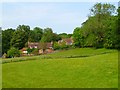
Pasture, woodland and cottages, Newtown
The area to the west of Newtown Common consists of paddocks and woodland interspersed with residences.
Image: © Andrew Smith
Taken: 4 Jun 2011
0.22 miles
5

Oakley Lane
Looking south west along Oakley Lane towards Penwood Road. A public footpath runs along the lane.
Image: © Oscar
Taken: 23 Feb 2023
0.25 miles