
IMAGES TAKEN NEAR TO
Adbury Holt, NEWBURY, RG20 9BW
Introduction
This page details the photographs taken nearby to Adbury Holt, RG20 9BW by members of the Geograph project.
The Geograph project started in 2005 with the aim of publishing, organising and preserving representative images for every square kilometre of Great Britain, Ireland and the Isle of Man.

There are currently over 7.5m images from over14,400 individuals and you can help contribute to the project by visiting https://www.geograph.org.uk
Image Map
Images are licensed for reuse under creativecommons.org/licenses/by-sa/2.0
Notes
- Clicking on the map will re-center to the selected point.
- The higher the marker number, the further away the image location is from the centre of the postcode.
Image Listing (18 Images Found)
Images are licensed for reuse under creativecommons.org/licenses/by-sa/2.0
Image
Details
Distance
1

Adbury Holt
Adbury Holt is a single track road off Well Street. It connects to Broken Way (a byway).
Image: © Oscar Taylor
Taken: 17 May 2023
0.05 miles
2

The Gables, Adbury Holt
The Gables is a detached house on Adbury Holt.
Image: © Oscar Taylor
Taken: 17 May 2023
0.05 miles
3

Pylons through Newtown Common
Electricity pylons cross Newtown Common, a nature reserve.
Image: © Oscar Taylor
Taken: 17 May 2023
0.08 miles
4

Adbury Holt sewage works
A small sewage works at the end of Adbury Holt. Very smelly!
Image: © Oscar Taylor
Taken: 17 May 2023
0.08 miles
5

Newtown Common footpath
A footpath through Newtown Common. Some of the routes are public footpaths, but have permitted riding marked by a black horseshoe on a white sign.
Image: © Oscar Taylor
Taken: 17 May 2023
0.08 miles
6

Broken Way (byway)
Broken Way is a byway between an unnamed road and Adbury Holt.
Image: © Oscar Taylor
Taken: 17 May 2023
0.11 miles
7

Heather and Gorse on Newtown Common
Heathland like this is quite a typical scene over a wide zone around here south of Newbury and stretching eastwards towards Aldershot and beyond. Sandy soils that were poor for agriculture remained sparsely populated for centuries until improved transport made housing development a better proposition.
Today, quite a lot still survives, either as forestry plantation, nature reserve, private woodland or common land as here.
Image: © Des Blenkinsopp
Taken: 10 May 2024
0.12 miles
8
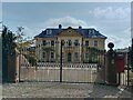
Adbury Court, Burghclere
Adbury Court is a modern building despite appearance, rebuilt in the 1990s after the old country house fell into disrepair after WWII. The building is of red brick with lime render.
Image: © Oscar Taylor
Taken: 17 May 2023
0.12 miles
9

Heathland, Newtown
Silver birches in an open area towards the southern edge of Newtown Common.
Image: © Andrew Smith
Taken: 8 Feb 2023
0.13 miles
10

Newtown Common footpath
A footpath through Newtown Common. Some of the routes are public footpaths, but have permitted riding marked by a black horseshoe on a white sign.
Image: © Oscar Taylor
Taken: 17 May 2023
0.16 miles