
IMAGES TAKEN NEAR TO
Warnham Lane, NEWBURY, RG20 7PW
Introduction
This page details the photographs taken nearby to Warnham Lane, RG20 7PW by members of the Geograph project.
The Geograph project started in 2005 with the aim of publishing, organising and preserving representative images for every square kilometre of Great Britain, Ireland and the Isle of Man.

There are currently over 7.5m images from over14,400 individuals and you can help contribute to the project by visiting https://www.geograph.org.uk
Image Map
Images are licensed for reuse under creativecommons.org/licenses/by-sa/2.0
Notes
- Clicking on the map will re-center to the selected point.
- The higher the marker number, the further away the image location is from the centre of the postcode.
Image Listing (11 Images Found)
Images are licensed for reuse under creativecommons.org/licenses/by-sa/2.0
Image
Details
Distance
1

Farmland below Cow Down
On the northern slope of Cow Down, with Compton to the left.
Image: © Graham Horn
Taken: 9 Jul 2009
0.08 miles
2

Field off Cheseridge Road
Warnhams Cottages can be glimpsed to the left. The line of trees beyond the cottages marks the Warnhams Lane byway.
Image: © Fly
Taken: 1 Oct 2011
0.10 miles
3

Warnham Lane
This is a Byway heading west from the north-east corner of the square. It technically can take vehicles, but there is a restriction a few hundred metres west so is usually used just by horses and walkers.
Image: © Graham Horn
Taken: 9 Jul 2009
0.13 miles

5

Track off Cheseridge Road
A private track accessing arable farmland and downland.
Image: © Graham Horn
Taken: 9 Jul 2009
0.17 miles
6
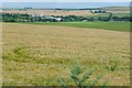
Crop at Cheseridge Farm
Looking north-east from just within the square (checked with GPS) with the buildings of the farm behind me. The square is mainly arable farmland. The buildings in the distance are part of the Agricultural Research Centre at Compton in Image
Image: © Graham Horn
Taken: 9 Jul 2009
0.17 miles


9

Haystack at Cheseridge Farm
This square is basically farm land and this farm is in the north eastern section of the square. These buildings are not used much any more as the farm has constructed new buildings elsewhere on the farm. The farm specialised in wheat and dairy farming.
Image: © Pam Brophy
Taken: 22 Jun 2005
0.23 miles
10

Cheseridge Farm
The farm is mixed, arable fields and cattle in these barns.
Image: © Graham Horn
Taken: 9 Jul 2009
0.24 miles