
IMAGES TAKEN NEAR TO
Peasemore, NEWBURY, RG20 7JU
Introduction
This page details the photographs taken nearby to RG20 7JU by members of the Geograph project.
The Geograph project started in 2005 with the aim of publishing, organising and preserving representative images for every square kilometre of Great Britain, Ireland and the Isle of Man.

There are currently over 7.5m images from over14,400 individuals and you can help contribute to the project by visiting https://www.geograph.org.uk
Image Map
Images are licensed for reuse under creativecommons.org/licenses/by-sa/2.0
Notes
- Clicking on the map will re-center to the selected point.
- The higher the marker number, the further away the image location is from the centre of the postcode.
Image Listing (15 Images Found)
Images are licensed for reuse under creativecommons.org/licenses/by-sa/2.0
Image
Details
Distance
1
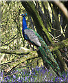
Peacock in Hailey Copse
I wouldn't have said this was Peacock country.
Not that I know what Peacock country is.
Just that I wouldn't have said this was it.
Image: © Des Blenkinsopp
Taken: 20 Apr 2016
0.08 miles
2

Farmland near Stanmore
This square is all farmland, but also has the intersection of two minor roads and the Downland Riding Route. This view is of a field to the north of Hailey land and south of the minor road leading to Brightwalton in the north west.
Image: © Pam Brophy
Taken: 17 Aug 2005
0.08 miles

4

Old Street Lane
A seasonal public byway.
Image: © Robin Webster
Taken: 18 May 2014
0.12 miles
5

Junction of Hailey and Sheep Leaze Lanes
Unlike the earlier submissions for this junction there is a diversion in place.
Image: © Shazz
Taken: 21 Jun 2013
0.12 miles


8

Five way junction on Stanmore Road
Initially it seems like a commonplace Y junction with the right fork leading up Sheepleaze Lane towards Lilley and the left fork leading to Peasemore via Hailey Lane. however for equestrians and walkers there are two more choices: right on The Broadway or left onto Old Street Lane.
Image: © Stuart Logan
Taken: 12 Apr 2011
0.14 miles
9

The Orange Way after Wiltshire (102)
The Orange Way crosses Hailey Lane.
To proceed to the next section of the Orange Way go to www.geograph.org.uk/geotrips/603.
Image: © Shazz
Taken: 21 Jun 2013
0.15 miles
