IMAGES TAKEN NEAR TO
Sandleford Lodge Park, THATCHAM, RG19 8XL
Introduction
This page details the photographs taken nearby to Sandleford Lodge Park, RG19 8XL by members of the Geograph project.
The Geograph project started in 2005 with the aim of publishing, organising and preserving representative images for every square kilometre of Great Britain, Ireland and the Isle of Man.

There are currently over 7.5m images from over14,400 individuals and you can help contribute to the project by visiting https://www.geograph.org.uk
Image Map
Images are licensed for reuse under creativecommons.org/licenses/by-sa/2.0
Notes
- Clicking on the map will re-center to the selected point.
- The higher the marker number, the further away the image location is from the centre of the postcode.
Image Listing (17 Images Found)
Images are licensed for reuse under creativecommons.org/licenses/by-sa/2.0
Image
Details
Distance
1
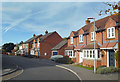
New Houses on Deadmans Lane
I am guessing this is the name of the road from before the houses were built. It doesn't sound like a name developers would select if they were given the choice.
Image: © Des Blenkinsopp
Taken: 24 Oct 2018
0.12 miles
2
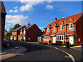
Modern Housing Development
New houses in the north eastern section of the square.
Image: © Pam Brophy
Taken: 12 Sep 2005
0.15 miles

5
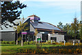
Premier Inn (Town Centre South)
There are two Premier Inns in Newbury. This one on the edge of town trades as Newbury Town Centre South, presumably to avoid confusion with the Newbury Town Centre branch which is.....err....in the town centre.
Image: © Des Blenkinsopp
Taken: 24 Oct 2018
0.17 miles
6
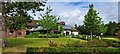
St. Gabriel's school
An independent school for girls aged 3 to 18, in the buildings of the former Sandleford Priory. Their website is here http://www.stgabriels.co.uk/page_viewer.asp?page=Home&pid=1
Image: © Graham Horn
Taken: 31 Jan 2009
0.18 miles
8
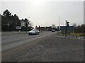
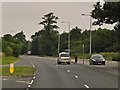
A339 south
Looking south on the A339 past the new road, Highwood Copse Way.
Image: © Oscar Taylor
Taken: 15 Mar 2023
0.19 miles
9
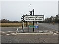
Highwood Copse signs
A very large sign for Highwood Copse Primary School and another for Highwood Copse Way.
Image: © Oscar Taylor
Taken: 15 Mar 2023
0.20 miles
10
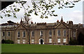
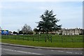
Sandleford Priory, Newbury
The priory was abandoned in 1478 and what we see now is an example of James Wyatt's Gothic style. The rendered front is not particularly attractive but the roofline is enlivened by crenellations and pinnacles. Grade I listed.
It is now occupied by St Gabriel's Girls' School.
The date of the photo is uncertain.
Image: © Stephen Richards
Taken: Unknown
0.21 miles