IMAGES TAKEN NEAR TO
Heath Lane, THATCHAM, RG18 3FD
Introduction
This page details the photographs taken nearby to Heath Lane, RG18 3FD by members of the Geograph project.
The Geograph project started in 2005 with the aim of publishing, organising and preserving representative images for every square kilometre of Great Britain, Ireland and the Isle of Man.

There are currently over 7.5m images from over14,400 individuals and you can help contribute to the project by visiting https://www.geograph.org.uk
Image Map
Images are licensed for reuse under creativecommons.org/licenses/by-sa/2.0
Notes
- Clicking on the map will re-center to the selected point.
- The higher the marker number, the further away the image location is from the centre of the postcode.
Image Listing (11 Images Found)
Images are licensed for reuse under creativecommons.org/licenses/by-sa/2.0
Image
Details
Distance
5

Thatcham Sky
Taken in July 2012, during the rainy season!
Image: © Rosa Foulger
Taken: 11 Jul 2012
0.06 miles
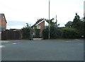
6
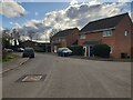
Billington Way
Looking towards Heath Lane on Billington Way.
Image: © Oscar
Taken: 22 Feb 2023
0.09 miles
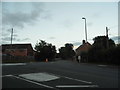
7

Billington Way
Looking towards the junction with Maynard Close on Billington Way.
Image: © Oscar
Taken: 22 Feb 2023
0.12 miles
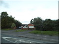
8
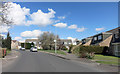
Sagecroft Road, Thatcham
If you leave the auto-correct on, it will turn this into Stagecraft Road.
I expect the people here find that out quite quickly.
Image: © Des Blenkinsopp
Taken: 5 Apr 2016
0.13 miles
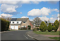
9
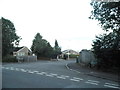
Norlands at the junction of Heath Lane
Image: © David Howard
Taken: 30 Jul 2017
0.14 miles
10
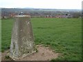
Thatcham
Thatcham seen from the top of the hill by the trig point.
Image: © Andy Malbon
Taken: 9 Apr 2005
0.17 miles