IMAGES TAKEN NEAR TO
Bryants Lane, THATCHAM, RG18 0XL
Introduction
This page details the photographs taken nearby to Bryants Lane, RG18 0XL by members of the Geograph project.
The Geograph project started in 2005 with the aim of publishing, organising and preserving representative images for every square kilometre of Great Britain, Ireland and the Isle of Man.

There are currently over 7.5m images from over14,400 individuals and you can help contribute to the project by visiting https://www.geograph.org.uk
Image Map
Images are licensed for reuse under creativecommons.org/licenses/by-sa/2.0
Notes
- Clicking on the map will re-center to the selected point.
- The higher the marker number, the further away the image location is from the centre of the postcode.
Image Listing (172 Images Found)
Images are licensed for reuse under creativecommons.org/licenses/by-sa/2.0
Image
Details
Distance
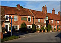
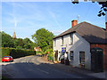
1
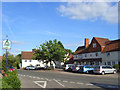
The Square, Yattendon
The small village is relatively well catered for (better than larger ones nearby) with general store and post office right of centre here. There is also a butcher's/greengrocer's in the cottage to the left. The Square also a hairdresser's and pub as well as an array of cottages. The road going from right to left is the main one through the village.
Image: © Andrew Smith
Taken: 30 Jun 2008
0.04 miles
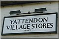
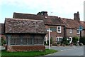
2
Yattendon stores
Opened in 1877, on the south side of the village square.
Image: © Graham Horn
Taken: 29 Sep 2008
0.04 miles
3
Yattendon village stores
The store can be seen in context here Image]
Image: © Graham Horn
Taken: 29 Sep 2008
0.04 miles
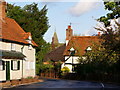
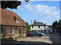
6
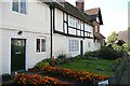
Houses in Yattendon
On the south side of the village square adjacent to the shop. These are all Yattendon estate houses, hence the green doors. Talking to the couple who live here they said they can now have any colour interiors, but cannot replace the rather draughty windows. There are no restrictions on what they plant in their garden. The oldest house is the one with the timber frame. The brick one on the end used to be the coach house.
Image: © Graham Horn
Taken: 29 Sep 2008
0.05 miles
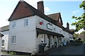
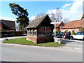
7
The Royal Oak and bus shelter
The west end of the square in Yattendon.
Image: © Graham Horn
Taken: 29 Sep 2008
0.05 miles
9
West Berkshire Brewery, Yattendon
The brewery was established in 1995. It appears that they have won many awards and they moved into these larger premises from neighbouring Frilsham. The spire of St Peter and St Paul's church can be seen. This was added to the building in 1896 by Alfred Waterhouse. The famous Victorian architect built nearby Yattendon Court for himself. Beside the brewery is a dark green telephone box.
Image: © Andrew Smith
Taken: 30 Jun 2008
0.05 miles
10
Village hall and brewery, Yattendon
The West Berkshire Brewery, established in 1995, is the white building. It stands on the Bradfield/Pangbourne/Reading road just west of the village centre.
Image: © Andrew Smith
Taken: 30 Jun 2008
0.05 miles