IMAGES TAKEN NEAR TO
Salisbury Road, HUNGERFORD, RG17 0RF
Introduction
This page details the photographs taken nearby to Salisbury Road, RG17 0RF by members of the Geograph project.
The Geograph project started in 2005 with the aim of publishing, organising and preserving representative images for every square kilometre of Great Britain, Ireland and the Isle of Man.

There are currently over 7.5m images from over14,400 individuals and you can help contribute to the project by visiting https://www.geograph.org.uk
Image Map
Images are licensed for reuse under creativecommons.org/licenses/by-sa/2.0
Notes
- Clicking on the map will re-center to the selected point.
- The higher the marker number, the further away the image location is from the centre of the postcode.
Image Listing (5 Images Found)
Images are licensed for reuse under creativecommons.org/licenses/by-sa/2.0
Image
Details
Distance
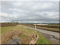
1
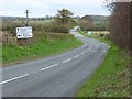
The A338, Shalbourne
Heading towards Hungerford. The road enters Berkshire where the cars are - on the northern edge of this grid-square.
Image: © Andrew Smith
Taken: 5 Apr 2008
0.09 miles
3
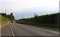
Lane to A338
A lane north of Ham to the A338.
Image: © Oscar Taylor
Taken: 30 Apr 2023
0.17 miles
4
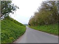
A338 towards Hungerford
Ahead is Doves Farm.
Image: © Robin Webster
Taken: 13 Jan 2023
0.18 miles
5
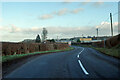
Cutting Hill
A view along Cutting Hill. To the left is farmland and the large building in the distance is Doves Farm Foods Ltd, a food manufacturer.
Image: © Oscar
Taken: 22 Feb 2023
0.25 miles