IMAGES TAKEN NEAR TO
Rupert Walk, READING, RG1 3HF
Introduction
This page details the photographs taken nearby to Rupert Walk, RG1 3HF by members of the Geograph project.
The Geograph project started in 2005 with the aim of publishing, organising and preserving representative images for every square kilometre of Great Britain, Ireland and the Isle of Man.

There are currently over 7.5m images from over14,400 individuals and you can help contribute to the project by visiting https://www.geograph.org.uk
Image Map
Images are licensed for reuse under creativecommons.org/licenses/by-sa/2.0
Notes
- Clicking on the map will re-center to the selected point.
- The higher the marker number, the further away the image location is from the centre of the postcode.
Image Listing (182 Images Found)
Images are licensed for reuse under creativecommons.org/licenses/by-sa/2.0
Image
Details
Distance
1
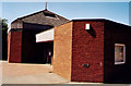
A building between Sun Street and St. John's School playing fields
The building in the background was the Plasterers Arms which closed in the 1990s. It is now the site of a flats.
Image: © Roger A Smith
Taken: 1 Jul 1997
0.02 miles
2
Junction of Woodstock Street and Cumberland Road
The house on the corner, #2 Woodstock Road had an OS benchmark (see http://www.bench-marks.org.uk/bm23685 ), but this appears to have been lost to rebuilding works.
Image: © Roger Templeman
Taken: 31 Aug 2011
0.05 miles
3
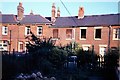
Cumberland Road, Reading
Looking up the street from the River Kennet. School Terrace goes off to the left.
Image: © Andrew Smith
Taken: 6 Sep 2007
0.06 miles
4
Cumberland Road, Reading
The lower end of the road just above the Kennet, showing the junction with School Terrace from the junction with Avon Place.
Image: © Andrew Smith
Taken: 28 Apr 2008
0.06 miles
5
St John & St Stephen, Reading
Erected in 1977.
Image: © Michael FORD
Taken: Unknown
0.06 miles
6

Carpark entrance on south side of Orts Road
Back of Wycliffe Baptist Church in middle ground.
Image: © Roger Templeman
Taken: 31 Aug 2011
0.07 miles
7
Albert Road Reading
The Anglers Arms and emptying houses opposite 61 Albert Road as Newtown residents are starting to be rehoused.
Image: © norman griffin
Taken: 1 Aug 1977
0.08 miles
8
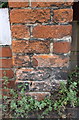
Site of benchmark on party wall of Nos. 127/129 Amity Road
Possibly the remains of the Ordnance Survey cut mark benchmark described on the Bench Mark Database at http://www.bench-marks.org.uk/bm23686 on the left hand side of the third brick above the pavement?
Image: © Roger Templeman
Taken: 21 Jul 2014
0.09 miles
9
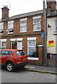
Houses on Amity Road
The party wall end pier left of the 'For Sale' sign may have the remains of an OS benchmark Image
Image: © Roger Templeman
Taken: 21 Jul 2014
0.09 miles
10
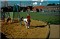
The playing fields of St. John's school
Image: © Roger A Smith
Taken: 29 Jul 1997
0.09 miles