IMAGES TAKEN NEAR TO
RG12 6LN
Introduction
This page details the photographs taken nearby to RG12 6LN by members of the Geograph project.
The Geograph project started in 2005 with the aim of publishing, organising and preserving representative images for every square kilometre of Great Britain, Ireland and the Isle of Man.

There are currently over 7.5m images from over14,400 individuals and you can help contribute to the project by visiting https://www.geograph.org.uk
Image Map
Images are licensed for reuse under creativecommons.org/licenses/by-sa/2.0
Notes
- Clicking on the map will re-center to the selected point.
- The higher the marker number, the further away the image location is from the centre of the postcode.
Image Listing (8 Images Found)
Images are licensed for reuse under creativecommons.org/licenses/by-sa/2.0
Image
Details
Distance
1
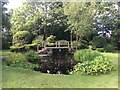
Ornamental pond and footbridge
In the grounds of Stirrups Country House Hotel
Image: © Graham Hogg
Taken: 21 May 2017
0.11 miles
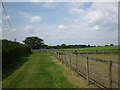
2
Footpath at Maiden's Green
The path has a wildlife corridor along its whole length.
Image: © don cload
Taken: 14 May 2010
0.12 miles
3
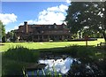
The Stirrups Country House Hotel
Photo taken from a bridge over a small pond, probably built to provide an attractive location for wedding photography.
Image: © Graham Hogg
Taken: 21 May 2017
0.14 miles
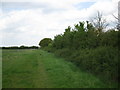
4
Footpath from Brock Hill to Warfield
A grassy path shortly after the entrance to Brockhill Stables.
Image: © don cload
Taken: 14 May 2010
0.19 miles
5
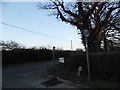
Parker's Lane at the junction of Bracknell Road
Image: © David Howard
Taken: 9 Mar 2014
0.23 miles
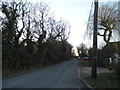
7
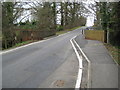
Winkfield Row
Winkfield Row is one of those places where the name of the village and the name of the road are the same. This is the B3017 Winkfield Row in Winkfield Row at the point where the road narrows for the bridge over The Cut.
Image: © Nigel Cox
Taken: 12 Mar 2009
0.24 miles
8
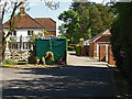
Parkers Lane, Winkfield
The access road to the High Pines mobile home park near Winkfield.
Image: © Alan Hunt
Taken: 13 May 2015
0.25 miles