IMAGES TAKEN NEAR TO
Lime Tree Close, READING, RG10 9FH
Introduction
This page details the photographs taken nearby to Lime Tree Close, RG10 9FH by members of the Geograph project.
The Geograph project started in 2005 with the aim of publishing, organising and preserving representative images for every square kilometre of Great Britain, Ireland and the Isle of Man.

There are currently over 7.5m images from over14,400 individuals and you can help contribute to the project by visiting https://www.geograph.org.uk
Image Map
Images are licensed for reuse under creativecommons.org/licenses/by-sa/2.0
Notes
- Clicking on the map will re-center to the selected point.
- The higher the marker number, the further away the image location is from the centre of the postcode.
Image Listing (28 Images Found)
Images are licensed for reuse under creativecommons.org/licenses/by-sa/2.0
Image
Details
Distance
1
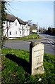
Milestone on the Old Bath Road
Now bypassed, this is still called Old Bath Road and used to be one of the most important roads in the land back in coaching days.
Image: © Des Blenkinsopp
Taken: 18 Feb 2013
0.04 miles
2
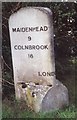
Old Milestone by the A3032 in Charvil
Carved stone post by the A3032, in parish of Sonning (Wokingham District), Old Bath Road; Charvil roundabout, by petrol station, on the verge between petrol station and the Wee Waif Lodge Motel, on North side of road. Bath Road limestone facets, erected by the Twyford turnpike trust in the 20th century.
Inscription reads:-
: MAIDENHEAD / 9 / COLNBROOK / 18 : : LONDON 35 :
: READING / 4 / NEWBURY / 21 / BATH 73 :
Grade II listed.
List Entry Number: 1135884 https://historicengland.org.uk/listing/the-list/list-entry/1135884
Milestone Society National ID: BE_LB35
Image: © A Rosevear
Taken: 10 Aug 2001
0.05 miles
3
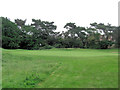
Sonning Golf Course 6th green
The houses behind this green are on the Old Bath Road. Holes at Sonning have been renumbered of late, after improvements to the course. This is the erstwhile 13th, a par 5 of 482 yards and stroke index 12 (ie. the 12th most difficult). It's fairway crests and descends Charvil Hill.
Image: © Stuart Logan
Taken: 7 Jun 2012
0.05 miles
4
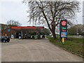
Forecourt on a Texaco fuel station on the A4 at Sonning
Image: © Rod Allday
Taken: 22 Apr 2023
0.08 miles
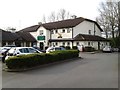


8
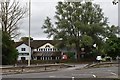
The Wee Waif Hotel, Charvil
A pub was first built on this site, on the corner of Bath Road and Milestone Avenue in the 1920s.
Image: © Simon Mortimer
Taken: 4 Jul 2020
0.09 miles
9
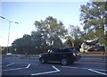
The A4 in Charvil
Looking towards the Wee Waif Hotel
Image: © David Howard
Taken: 9 Aug 2015
0.09 miles