IMAGES TAKEN NEAR TO
Purfield Drive, READING, RG10 8AP
Introduction
This page details the photographs taken nearby to Purfield Drive, RG10 8AP by members of the Geograph project.
The Geograph project started in 2005 with the aim of publishing, organising and preserving representative images for every square kilometre of Great Britain, Ireland and the Isle of Man.

There are currently over 7.5m images from over14,400 individuals and you can help contribute to the project by visiting https://www.geograph.org.uk
Image Map
Images are licensed for reuse under creativecommons.org/licenses/by-sa/2.0
Notes
- Clicking on the map will re-center to the selected point.
- The higher the marker number, the further away the image location is from the centre of the postcode.
Image Listing (15 Images Found)
Images are licensed for reuse under creativecommons.org/licenses/by-sa/2.0
Image
Details
Distance
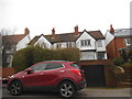
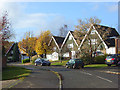
1
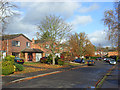
Purfield Drive, Wargrave
A winding residential road linking Victoria Road and Blakes Road.
Image: © Andrew Smith
Taken: 8 Nov 2008
0.02 miles
2
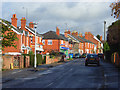
Victoria Road, Wargrave
The scene here features the village's post office and a convenience store. There was, until recently, also a post office in the village centre but that was a victim of the recent round of closures.
Image: © Andrew Smith
Taken: 8 Nov 2008
0.06 miles
3
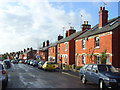
Victoria Road, Wargrave
Upper Wargrave has grown up around these late Victorian cottages. They were originally part of a linear development to the east of the village centre. These cottages are dated in the 1890s.
Image: © Andrew Smith
Taken: 8 Nov 2008
0.06 miles
4
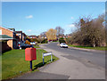
Purfield Drive, Wargrave
This is part of National Cycle Route 4 between London and Fishguard. There are no special cycle facilities but it is a quiet street avoiding the town centre.
Royal Mail drop box on the corner.
Image: © Des Blenkinsopp
Taken: 18 Feb 2013
0.07 miles
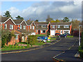
6
Fidler's Walk, Wargrave
A cul-de-sac of mostly chalet-style bungalows off Purfield Drive.
Image: © Andrew Smith
Taken: 8 Nov 2008
0.11 miles
7
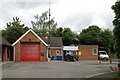
Wargrave Fire Station
Wargrave Fire Station, Victoria Road, Wargrave, Berkshire
Image: © Kevin Hale
Taken: 8 May 2007
0.11 miles
8
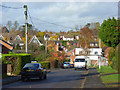
Upper Wargrave
A view over the eastern part of Wargrave, the vast majority of which is post-war housing, from Hamilton Road.
Image: © Andrew Smith
Taken: 8 Nov 2008
0.12 miles
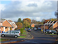
9
Langham's Way, Wargrave
Part of the post-war residential development of Upper Wargrave.
Image: © Andrew Smith
Taken: 8 Nov 2008
0.12 miles
10
Newall's Rise, Wargrave
An L-shaped cul-de-sac off Purfield Drive.
Image: © Andrew Smith
Taken: 8 Nov 2008
0.12 miles