IMAGES TAKEN NEAR TO
Northam Close, SOUTHPORT, PR9 9GA
Introduction
This page details the photographs taken nearby to Northam Close, PR9 9GA by members of the Geograph project.
The Geograph project started in 2005 with the aim of publishing, organising and preserving representative images for every square kilometre of Great Britain, Ireland and the Isle of Man.

There are currently over 7.5m images from over14,400 individuals and you can help contribute to the project by visiting https://www.geograph.org.uk
Image Map
Images are licensed for reuse under creativecommons.org/licenses/by-sa/2.0
Notes
- Clicking on the map will re-center to the selected point.
- The higher the marker number, the further away the image location is from the centre of the postcode.
Image Listing (7 Images Found)
Images are licensed for reuse under creativecommons.org/licenses/by-sa/2.0
Image
Details
Distance
1
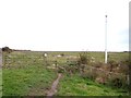
Stile and vent on path around Crossens Marsh
Image: © Raymond Knapman
Taken: 7 Nov 2008
0.08 miles
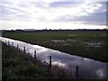
2
Old Bank at Marshside
This was the sea defence bank until the construction of the Marine Drive some years ago. The land reclaimed, on the left, is now a bird reserve managed by the R.S.P.B. The public footpath along the top of the bank is now part of the Sefton Coastal Footpath
Image: © K A
Taken: 11 Jun 2011
0.12 miles
3
Marshside, Southport
View across Marshside towards Hesketh golf course with gas tower on horizon.
Image: © Mark Arrowsmith
Taken: 10 Dec 2005
0.13 miles
4
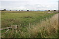
Crossens Marsh
Managed by the RSPB as part of Marshside nature reserve.
Image: © Mike Pennington
Taken: 19 Oct 2015
0.14 miles
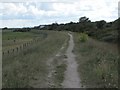
5
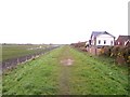
Path around Crossens Marsh
Path follows top of dyke
Image: © Raymond Knapman
Taken: 7 Nov 2008
0.16 miles

7
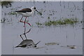
Black-winged Stilt (Himantopus himantopus), Marshside
A rare visitor from southern Europe.
Image: © Mike Pennington
Taken: 26 Apr 2022
0.24 miles