IMAGES TAKEN NEAR TO
Russell Road, SOUTHPORT, PR9 7SY
Introduction
This page details the photographs taken nearby to Russell Road, PR9 7SY by members of the Geograph project.
The Geograph project started in 2005 with the aim of publishing, organising and preserving representative images for every square kilometre of Great Britain, Ireland and the Isle of Man.

There are currently over 7.5m images from over14,400 individuals and you can help contribute to the project by visiting https://www.geograph.org.uk
Image Map (Loading...)


Getting Data...Please wait
Leaflet Map data © OpenStreetMap
Images are licensed for reuse under creativecommons.org/licenses/by-sa/2.0
Notes
- Clicking on the map will re-center to the selected point.
- The higher the marker number, the further away the image location is from the centre of the postcode.
Image Listing (18 Images Found)
Images are licensed for reuse under creativecommons.org/licenses/by-sa/2.0
Image
Details
Distance
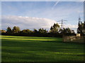
1
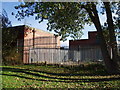
Fenced Off
Southeast view of Southport electricity grid substation.
Image: © J Scott
Taken: 20 Oct 2005
0.04 miles
2
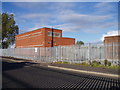
The Grid At Southport
Southport electricity grid substation.
Image: © J Scott
Taken: 20 Oct 2005
0.05 miles
3
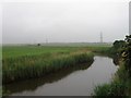
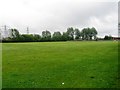
Green Scene
Playing field fronting the grid substation.
Image: © J Scott
Taken: 20 Oct 2005
0.08 miles
4
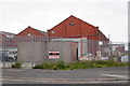
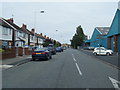
Blowick Industrial Estate, Southport
Image: © Mike Pennington
Taken: 8 Jul 2016
0.08 miles
5
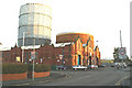
At your service
Southport's gasometers, visible from miles away, loom over the bus sheds at Blowick.
Image: © David Long
Taken: 11 Jan 2006
0.11 miles
6
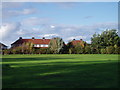
Terrace Green
Playing field to the rear of Montgomery Avenue.
Image: © J Scott
Taken: 20 Oct 2005
0.12 miles
8
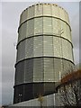
High Park Gasworks
Taken on a sunny winter afternoon looking up at the tower from the road below.
Image: © graeme murray
Taken: 22 Nov 2007
0.14 miles