IMAGES TAKEN NEAR TO
Russell Avenue, SOUTHPORT, PR9 7RD
Introduction
This page details the photographs taken nearby to Russell Avenue, PR9 7RD by members of the Geograph project.
The Geograph project started in 2005 with the aim of publishing, organising and preserving representative images for every square kilometre of Great Britain, Ireland and the Isle of Man.

There are currently over 7.5m images from over14,400 individuals and you can help contribute to the project by visiting https://www.geograph.org.uk
Image Map (Loading...)


Getting Data...Please wait
Leaflet Map data © OpenStreetMap
Images are licensed for reuse under creativecommons.org/licenses/by-sa/2.0
Notes
- Clicking on the map will re-center to the selected point.
- The higher the marker number, the further away the image location is from the centre of the postcode.
Image Listing (10 Images Found)
Images are licensed for reuse under creativecommons.org/licenses/by-sa/2.0
Image
Details
Distance
1
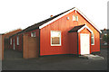
Tidy tin tabernacle
Even though it's well over a century old, this example of the hundreds such 'temporary' chapels erected in the last quarter of the 19th century is well looked after - and, as the wheelchair ramp shows, still fit for the purpose.
Image: © David Long
Taken: 11 Jan 2006
0.13 miles
4
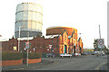
At your service
Southport's gasometers, visible from miles away, loom over the bus sheds at Blowick.
Image: © David Long
Taken: 11 Jan 2006
0.14 miles
5
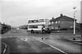
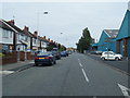
Suburban Southport ? 1966
Leyland PD2 bus with Weymann bodywork operating on service 7 at the junction of Cobden Road and Canning Road.
This is one of a series of views featuring buses in the 60s, 70s, and 80s.
http://www.geograph.org.uk/search.php?i=2114547&displayclass=slide
Image: © Alan Murray-Rust
Taken: 26 Feb 1966
0.20 miles
6
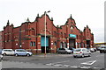
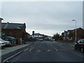
Canning Road Bus Depot
The former depot of Southport Corporation Buses which now carries the Arriva logo on the frontage
Image: © K A
Taken: 14 May 2013
0.20 miles
7
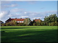
Terrace Green
Playing field to the rear of Montgomery Avenue.
Image: © J Scott
Taken: 20 Oct 2005
0.21 miles
9
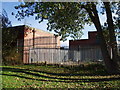
Fenced Off
Southeast view of Southport electricity grid substation.
Image: © J Scott
Taken: 20 Oct 2005
0.23 miles
10
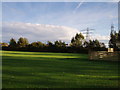
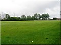
Green Scene
Playing field fronting the grid substation.
Image: © J Scott
Taken: 20 Oct 2005
0.23 miles