IMAGES TAKEN NEAR TO
Fisher Drive, SOUTHPORT, PR9 7DS
Introduction
This page details the photographs taken nearby to Fisher Drive, PR9 7DS by members of the Geograph project.
The Geograph project started in 2005 with the aim of publishing, organising and preserving representative images for every square kilometre of Great Britain, Ireland and the Isle of Man.

There are currently over 7.5m images from over14,400 individuals and you can help contribute to the project by visiting https://www.geograph.org.uk
Image Map (Loading...)


Getting Data...Please wait
Leaflet Map data © OpenStreetMap
Images are licensed for reuse under creativecommons.org/licenses/by-sa/2.0
Notes
- Clicking on the map will re-center to the selected point.
- The higher the marker number, the further away the image location is from the centre of the postcode.
Image Listing (16 Images Found)
Images are licensed for reuse under creativecommons.org/licenses/by-sa/2.0
Image
Details
Distance
1
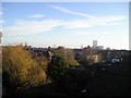
Gas Works
View South East across largely residential area to Blowick Gas Works.
Update, December 2009
The gas holders have now been demolished, the largest in 2009 April - see this gallery of "before" and "after" views: http://commons.wikimedia.org/wiki/Southport_gas_holder
Image: © Mark Arrowsmith
Taken: 11 Dec 2005
0.10 miles
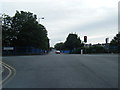
2

Former railway track at Norwood Crescent
The former Southport to Crossens and Preston railway (closed 1964) ran in a shallow cutting at this point immediately north of the junction of the western and eastern limbs of the Meols Cop "triangle". Unusually, this strip of former railway land has not been put to economic use but remains as unmanaged woodland. Seen from the footbridge linking Norwood Crescent and Grange Road.
Image: © Oliver Dixon
Taken: 20 Oct 2024
0.21 miles
4
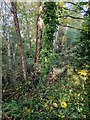
Former railway track at Norwood Crescent
The former Southport to Crossens and Preston railway (closed 1964) ran in a shallow cutting at this point immediately north of the junction of the western and eastern limbs of the Meols Cop "triangle". Unusually, this strip of former railway land which extends as far as Roe Lane has not been put to economic use but remains as unmanaged woodland. Seen from the footbridge linking Norwood Crescent and Grange Road.
Image: © Oliver Dixon
Taken: 20 Oct 2024
0.21 miles
7
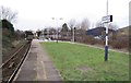
Meols Cop railway station, Lancashire
Opened in 1887 by the Liverpool, Southport and Preston Junction Railway (principally running north east-south west from Preston to Merseyside), this station has, by an accident of history and geography, ended up on the Wigan-Southport (south east - north west) line, replacing a small part of the Manchester and Southport Railway's original line. View north west towards Southport.
Image: © Nigel Thompson
Taken: 31 Dec 2009
0.23 miles
8
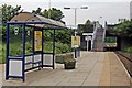
Meols Cop Railway Station
The island platform, with a shelter and the stairway from the main road. The B5276 Norwood Road bridge is at the end of the platform.
Image: © El Pollock
Taken: 13 Jun 2012
0.23 miles
9
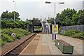
Southport-bound platform, Meols Cop Railway Station
Looking towards the B5276 road bridge.
Image: © El Pollock
Taken: 13 Jun 2012
0.23 miles
10
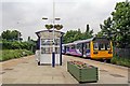
Railbus, Meols Cop Railway Station
Northern Rail unit 142044 is on the way through Meols Cop, bound for Wigan, after leaving Southport.
Image: © El Pollock
Taken: 13 Jun 2012
0.24 miles