IMAGES TAKEN NEAR TO
Kensington Road, SOUTHPORT, PR9 0RY
Introduction
This page details the photographs taken nearby to Kensington Road, PR9 0RY by members of the Geograph project.
The Geograph project started in 2005 with the aim of publishing, organising and preserving representative images for every square kilometre of Great Britain, Ireland and the Isle of Man.

There are currently over 7.5m images from over14,400 individuals and you can help contribute to the project by visiting https://www.geograph.org.uk
Image Map (Loading...)


Getting Data...Please wait
Leaflet Map data © OpenStreetMap
Images are licensed for reuse under creativecommons.org/licenses/by-sa/2.0
Notes
- Clicking on the map will re-center to the selected point.
- The higher the marker number, the further away the image location is from the centre of the postcode.
Image Listing (39 Images Found)
Images are licensed for reuse under creativecommons.org/licenses/by-sa/2.0
Image
Details
Distance
1
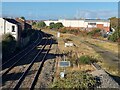
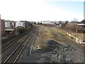
Railway west of Windsor Road foobridge
The live rails now only carry the Manchester to Southport service. From this point, the tracks originally fanned out to lines to Chapel Street station, the goods yard and Southport Central station (later Derby Road goods station). The area of the latter two is now occupied by the M Park Central 12 shopping centre (seen on the right) and adjoining car park. It is just possible to make out the Victoria footbridge in the distance.
Image: © Oliver Dixon
Taken: 22 Oct 2024
0.08 miles
2
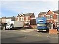
Business premises, Kensington Road, Southport
A large shop fitting business "Kiddie Shop Fitters" is based on this generally residential street in Southport. Hidden behind the houses, and accessed through the gap between them, is a large warehouse used by the business.
Image: © Graham Robson
Taken: 24 Mar 2018
0.09 miles
3
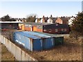
Industrial building off Windsor Road, Southport
An industrial building located between railway land and the back of a row of terraced houses. The site is accessed from Windsor Road and appears to belong to the Southport Bacon Company.
Image: © Graham Robson
Taken: 24 Mar 2018
0.11 miles
4
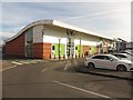
Stores at C12 Shopping Park, Southport
A row of 3 small retail units in the C12 Shopping Park close to Southport town centre. This small block contains branches of Mountain Warehouse, Costa Coffee and a still empty unit.
Image: © Graham Robson
Taken: 24 Mar 2018
0.11 miles
5
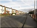
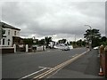
Kensington Road, Southport
A residential street close to the town centre.
Image: © Graham Robson
Taken: 24 Mar 2018
0.12 miles
6
Railway line to and from Southport
Looking down from a footbridge onto the railway line passing through a residential area close to Southport town centre.
Image: © Graham Robson
Taken: 24 Mar 2018
0.13 miles
7
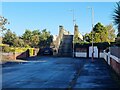
Steps up to the Windsor Road footbridge
Looking from the western (Hampton Road) end at the footbridge which spans the Southport to Manchester line. A bridge on this site was part of the infrastructure of the temporary Windsor Road station (1878-1882). Indeed judging from the state of the ironwork and the wear on the stone steps, this might well be the original unrenovated bridge from that era.
Image: © Oliver Dixon
Taken: 22 Oct 2024
0.14 miles
8
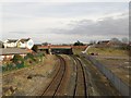
Railway line to and from Wigan, Southport
Looking from a footbridge crossing the tracks along the railway line between Southport and Wigan. The tracks are used by local stopping services carrying passengers to destinations in the North West of England, to Wigan and beyond. The road bridge in the distance carries Rose Hill over the railway lines.
Image: © Graham Robson
Taken: 24 Mar 2018
0.14 miles
9
Southport Carnival
Carnival float from Arden College on Derby Road leaving to join the procession.
Image: © Gerald England
Taken: 25 Jun 2000
0.15 miles
10
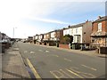
Virginia Street, Southport
Looking along a residential street inland from the town centre.
Image: © Graham Robson
Taken: 24 Mar 2018
0.16 miles