IMAGES TAKEN NEAR TO
Mount Terrace, SOUTHPORT, PR9 0RQ
Introduction
This page details the photographs taken nearby to Mount Terrace, PR9 0RQ by members of the Geograph project.
The Geograph project started in 2005 with the aim of publishing, organising and preserving representative images for every square kilometre of Great Britain, Ireland and the Isle of Man.

There are currently over 7.5m images from over14,400 individuals and you can help contribute to the project by visiting https://www.geograph.org.uk
Image Map (Loading...)


Getting Data...Please wait
Leaflet Map data © OpenStreetMap
Images are licensed for reuse under creativecommons.org/licenses/by-sa/2.0
Notes
- Clicking on the map will re-center to the selected point.
- The higher the marker number, the further away the image location is from the centre of the postcode.
Image Listing (23 Images Found)
Images are licensed for reuse under creativecommons.org/licenses/by-sa/2.0
Image
Details
Distance
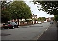
2
Junction of Marlborough Road and Manchester Road, Southport in 1976
1976 street scene at junction of Marlborough Road and Manchester Road in Southport. Just out of view is 'The Rabbit' public house.
Image: © Clint Mann
Taken: Unknown
0.05 miles
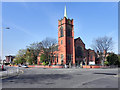
3
St Luke's Parish Church
This section of perimeter wall is often under repair due to road traffic accidents at this tricky junction.
Picture taken by Fenner.
Image: © Mark Arrowsmith
Taken: 10 Dec 2005
0.05 miles
5
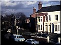
Hawkshead Street, Southport - Eastwards
Image: © Robert Whittingham
Taken: 22 Aug 2002
0.16 miles
6
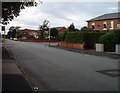
Hawkshead Street, Southport - looking West
Image: © Robert Whittingham
Taken: 22 Aug 2002
0.16 miles
7
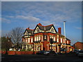
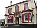
The Mount Pleasant Pub
The Mount Pleasant Pub on Manchester Road.
Image: © Sue Adair
Taken: 3 Jan 2010
0.18 miles
8
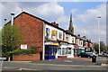
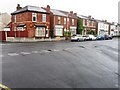
Row of shops on Manchester Road
The spire of Leyland Road Methodist Church is seen over the top of the shops
Image: © K A
Taken: 7 May 2013
0.18 miles
9
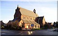
St Mark's Methodist Church, Southport
The former St Mark's Methodist Church, at the corner of Church Street and Derby Street is a Grade II Listed Building (http://www.britishlistedbuildings.co.uk/en-478964-st-marks-methodist-church-southport ) dating from around 1905. Since 2005, it has been in use as "St Mark's Medical Centre and Pharmacy" http://www.merseydoctors.nhs.uk/stmarks/practice/index.htm ).
Image: © David Dixon
Taken: 9 Apr 2011
0.20 miles
10
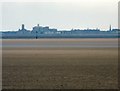
Southport from St Annes
Across Salter's Bank and the River Ribble to Southport with a telephoto lens. On the left is the tower of Holy Trinity Image On the right is the spire of St George's Image
Image: © Gerald England
Taken: 14 Apr 2012
0.22 miles