IMAGES TAKEN NEAR TO
Lime Street, SOUTHPORT, PR8 6BZ
Introduction
This page details the photographs taken nearby to Lime Street, PR8 6BZ by members of the Geograph project.
The Geograph project started in 2005 with the aim of publishing, organising and preserving representative images for every square kilometre of Great Britain, Ireland and the Isle of Man.

There are currently over 7.5m images from over14,400 individuals and you can help contribute to the project by visiting https://www.geograph.org.uk
Image Map (Loading...)


Getting Data...Please wait
Leaflet Map data © OpenStreetMap
Images are licensed for reuse under creativecommons.org/licenses/by-sa/2.0
Notes
- Clicking on the map will re-center to the selected point.
- The higher the marker number, the further away the image location is from the centre of the postcode.
Image Listing (4 Images Found)
Images are licensed for reuse under creativecommons.org/licenses/by-sa/2.0
Image
Details
Distance
2
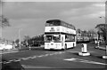
Leyland Atlantean demonstrator, Southport ? 1966
It was common practice for the large vehicle manufacturers, when a new model was just on the market, to have one available for operators to have on loan to evaluate. KTD 551C was just such a vehicle and is seen here on loan to Southport Corporation.
This is one of a series of views featuring buses in the 60s, 70s, and 80s.
http://www.geograph.org.uk/search.php?i=2114547&displayclass=slide
Image: © Alan Murray-Rust
Taken: 26 Feb 1966
0.18 miles