IMAGES TAKEN NEAR TO
Windermere Crescent, SOUTHPORT, PR8 3QS
Introduction
This page details the photographs taken nearby to Windermere Crescent, PR8 3QS by members of the Geograph project.
The Geograph project started in 2005 with the aim of publishing, organising and preserving representative images for every square kilometre of Great Britain, Ireland and the Isle of Man.

There are currently over 7.5m images from over14,400 individuals and you can help contribute to the project by visiting https://www.geograph.org.uk
Image Map
Images are licensed for reuse under creativecommons.org/licenses/by-sa/2.0
Notes
- Clicking on the map will re-center to the selected point.
- The higher the marker number, the further away the image location is from the centre of the postcode.
Image Listing (11 Images Found)
Images are licensed for reuse under creativecommons.org/licenses/by-sa/2.0
Image
Details
Distance
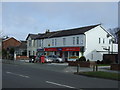
1
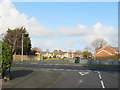
Gleneagles Drive, Ainsdale
View across road junction with houses and bus stop.
Image: © David Hawgood
Taken: 25 Dec 2014
0.12 miles
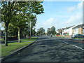
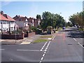
4

"Santa please stop here" notice in Ainsdale, 12 noon Christmas Day
The notice is put out every year and so far the request has always been successful.
Image: © David Hawgood
Taken: 25 Dec 2014
0.14 miles
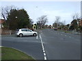
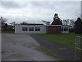
7
Liverpool Road at Woodvale
Meadow Lane joins on left of view
Image: © Raymond Knapman
Taken: 8 Aug 2012
0.17 miles
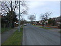
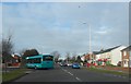
10
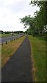
Cheshire Lines cycle path
The cycle path follows the coastal road towards Southport near Ainsdale.
Image: © Peter Mackenzie
Taken: 16 May 2017
0.23 miles