IMAGES TAKEN NEAR TO
Garrick Parade, Lord Street, SOUTHPORT, PR8 1RN
Introduction
This page details the photographs taken nearby to Garrick Parade, Lord Street, PR8 1RN by members of the Geograph project.
The Geograph project started in 2005 with the aim of publishing, organising and preserving representative images for every square kilometre of Great Britain, Ireland and the Isle of Man.

There are currently over 7.5m images from over14,400 individuals and you can help contribute to the project by visiting https://www.geograph.org.uk
Image Map
Images are licensed for reuse under creativecommons.org/licenses/by-sa/2.0
Notes
- Clicking on the map will re-center to the selected point.
- The higher the marker number, the further away the image location is from the centre of the postcode.
Image Listing (120 Images Found)
Images are licensed for reuse under creativecommons.org/licenses/by-sa/2.0
Image
Details
Distance
1
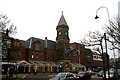
Southport (Lord Street) station
When the Southport and Cheshire Lines Extension Railway built its terminus in 1884, it did so on a grandiose scale, determined to outdo the rival Lancashire & Yorkshire terminus at Chapel Street. Not only was the SCELR station to be on Lord Street (the premier shopping street of the town) but it would have an overall glazed roof, five platforms, and an imposing frontage with a clock tower. However, the LYR had more routes than the SCELR, and Lord Street remained as not much more than an expensive curiosity, its finest hour coming in 1941 when the LYR line was temporarily disabled by enemy action.
After 1948, British Railways took a long and unsentimental look at Lord Street and in 1952 decided to close it. The station became a bus station, retaining its overall roof and little altered except for levelling of the platform area. Then in 1987 the bus station in its turn was closed, the overall roof demolished, and a Morrison's store built on the space. However, at the same time, the frontage was restored and remains intact today.
Image: © Dr Neil Clifton
Taken: 21 Mar 2009
0.01 miles
2
The Henry Segrave on Lord Street
The Henry Segrave is a Wetherspoon pub.
Image: © Steve Daniels
Taken: 5 Jun 2018
0.01 miles
3
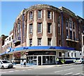
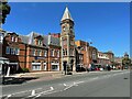
Garrick Theatre
According to the Theatres Trust http://www.theatrestrust.org.uk/resources/theatres/show/1987-garrick-southport it was "built on the site of the Opera House and said to be George Tonge's finest design. A massive building in red brick with stone dressings in what was described, loosely, as Italian Renaissance style, but actually a splendid Art Deco invention. Frontages to Lord Street and Kingsway are linked by a curved corner with skyscraper-like ornamental pilasters. Many tall windows with shouldered heads. The Lord Street entrance was originally surmounted by a high canopy with an open colonnade above at first floor which served as a promenade. The now modified foyer had a domed ceiling and niches in Egyptian style. Spectacular Art Deco auditorium has a rounded proscenium with a vast splayed anti-proscenium almost engulfing the four boxes on either side. ... The interior remains intact, save for modifications for bingo and alterations to the foyer. The stage is about 12m (c.40ft) deep with a 12m proscenium opening".
More information about its history and its use as a Bingo Hall can be found at http://web.archive.org/web/20090427092645/http://playingbingo.co.uk/bingo-history-folklore/03-southport-garrick-history-1.shtml
Image: © Gerald England
Taken: 10 Jul 2009
0.02 miles
4
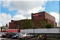
Rear of Mecca Bingo
The rear of the Mecca Bingo Hall (formerly the Garrick Theatre Image) from Morrisons car park.
Image: © Gerald England
Taken: 16 Jul 2010
0.02 miles
5
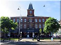
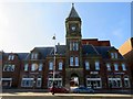
Southport Lord Street railway station (site), Merseyside, 2008
Opened in 1884 by the Cheshire Lines Committee as the terminus of its Southport & Cheshire Lines Extension Railway, this station closed in 1952.
View north at the frontage. After some years as a bus station, the train shed behind was demolished and the site had become a supermarket when this image was taken. Sometime later, the metal canopies were removed -see Image for a 2022 image from the same camera position.
For more information, see http://www.disused-stations.org.uk/s/southport_lord_street/index.shtml
Image: © Nigel Thompson
Taken: 9 Aug 2008
0.03 miles
6
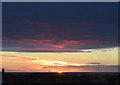
Southport Sunset
The view from my room on the 4th floor of Southport Travelodge. I watched the sun set over the sea, despite the houses in between. The flare or light on the right seemed to be a permanent fixture.
Image: © Keith Edkins
Taken: 8 Mar 2018
0.03 miles
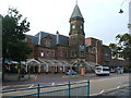
9
Southport Lord Street railway station (site), Merseyside
Opened in 1884 by the Cheshire Lines Committee as the terminus of its Southport & Cheshire Lines Extension Railway, this station closed in 1952.
View north at the frontage. After some years as a bus station, the train shed behind was demolished and the site had become a supermarket when this image was taken.
See Image for an earlier image from the same camera position. Only the clock tower and some floor tiling within it now survive. For more details, see http://www.disused-stations.org.uk/s/southport_lord_street/index.shtml
Image: © Nigel Thompson
Taken: 3 Aug 2022
0.04 miles