IMAGES TAKEN NEAR TO
Whinney Lane, CHORLEY, PR7 6DS
Introduction
This page details the photographs taken nearby to Whinney Lane, PR7 6DS by members of the Geograph project.
The Geograph project started in 2005 with the aim of publishing, organising and preserving representative images for every square kilometre of Great Britain, Ireland and the Isle of Man.

There are currently over 7.5m images from over14,400 individuals and you can help contribute to the project by visiting https://www.geograph.org.uk
Image Map
Images are licensed for reuse under creativecommons.org/licenses/by-sa/2.0
Notes
- Clicking on the map will re-center to the selected point.
- The higher the marker number, the further away the image location is from the centre of the postcode.
Image Listing (24 Images Found)
Images are licensed for reuse under creativecommons.org/licenses/by-sa/2.0
Image
Details
Distance
1
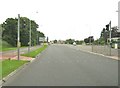
Pedestrian crossing on Euxton Lane
This a crossing with traffic lights.
Image: © Ann Cook
Taken: 11 Aug 2010
0.09 miles
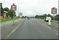
2
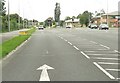
Traffic lights on Euxton Lane
The turning to the right leads to Buckshaw village.
Image: © Ann Cook
Taken: 11 Aug 2010
0.10 miles
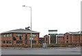
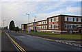
6
Runshaw College
Sixth Form, Adult, Higher Education and Business College.
Image: © David Dixon
Taken: 11 Jun 2014
0.16 miles
8
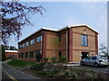
Office Block
The Ordnance Survey Office for Lancashire and Cumbria
Image: © Alexander P Kapp
Taken: 27 Apr 2007
0.17 miles
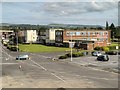
10
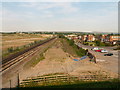
The site of Euxton railway station and the Royal Ordnance Factory
In the heyday of the surrounding Royal Ordnance factory, Euxton (pronounced x-ton not youx-ston) station was heavily used by workers travelling to and from work from the surrounding towns of Leyland and Chorley. The Royal Ordnance management offices are still present at the right of the picture and form a business park (now called Xton business park [groan]), the factory covered the whole area to the left of the picture. The station itself has been demolished (centre of the picture), although there is talk about building a new station here.
Image: © Martin Stockdale
Taken: 7 Jun 2005
0.20 miles