IMAGES TAKEN NEAR TO
Beechfields, CHORLEY, PR7 5RF
Introduction
This page details the photographs taken nearby to Beechfields, PR7 5RF by members of the Geograph project.
The Geograph project started in 2005 with the aim of publishing, organising and preserving representative images for every square kilometre of Great Britain, Ireland and the Isle of Man.

There are currently over 7.5m images from over14,400 individuals and you can help contribute to the project by visiting https://www.geograph.org.uk
Image Map
Images are licensed for reuse under creativecommons.org/licenses/by-sa/2.0
Notes
- Clicking on the map will re-center to the selected point.
- The higher the marker number, the further away the image location is from the centre of the postcode.
Image Listing (13 Images Found)
Images are licensed for reuse under creativecommons.org/licenses/by-sa/2.0
Image
Details
Distance
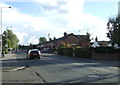
2
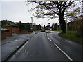
Doctors Lane, Eccleston
Heading east towards roundabout.
Image: © JThomas
Taken: 11 Oct 2014
0.12 miles
3
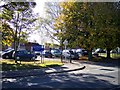
Autumn colour at Ecclestone Primary School
Image: © Raymond Knapman
Taken: 20 Oct 2010
0.12 miles
5
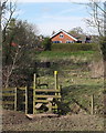
Footpath between Sherbourn House and Syd Brook, Eccleston
Image: © Gary Rogers
Taken: 13 Apr 2016
0.18 miles
6
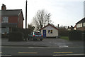
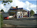
Bang on lunchtime
As I drew up outside the little village chippy, the car clock turned to 1pm.
Image: © David Long
Taken: 17 Jan 2006
0.18 miles
7
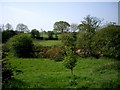
Rough pasture along Syd Brook, Eccleston
Image: © Tom Pennington
Taken: 7 May 2008
0.18 miles
8
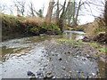
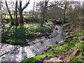
Syd Brook, Eccleston
Syd Brook west of Woodart Bridge. Syd Brook is a tributary of the River Yarrow which it joins at Home Farm.
Image: © Gary Rogers
Taken: 3 Jan 2015
0.19 miles
9
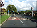
The Green, Eccleston (B5250)
Heading south east.
Image: © JThomas
Taken: 11 Oct 2014
0.21 miles