IMAGES TAKEN NEAR TO
Glenmore, CHORLEY, PR6 7TA
Introduction
This page details the photographs taken nearby to Glenmore, PR6 7TA by members of the Geograph project.
The Geograph project started in 2005 with the aim of publishing, organising and preserving representative images for every square kilometre of Great Britain, Ireland and the Isle of Man.

There are currently over 7.5m images from over14,400 individuals and you can help contribute to the project by visiting https://www.geograph.org.uk
Image Map
Images are licensed for reuse under creativecommons.org/licenses/by-sa/2.0
Notes
- Clicking on the map will re-center to the selected point.
- The higher the marker number, the further away the image location is from the centre of the postcode.
Image Listing (43 Images Found)
Images are licensed for reuse under creativecommons.org/licenses/by-sa/2.0
Image
Details
Distance
![Sheep Hill Lane [B5256]](https://s1.geograph.org.uk/geophotos/02/02/82/2028217_20ddd1ae_120x120.jpg)
2
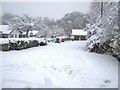
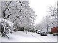
Beechwood Croft
This view is taken from Woodend Road.
Image: © Ann Cook
Taken: 5 Jan 2010
0.10 miles
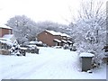
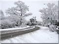
3
Midday Christmas 2010 - Pingle Croft, Clayton-le-Woods
No snow has fallen for 8 days but everything is still white. The snow hasn't melted because the temperatures have been sub-zero for days and days!
Image: © Ann Cook
Taken: 25 Dec 2010
0.10 miles
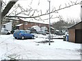
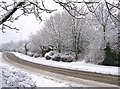
4
Pingle Croft
This is a little cul-de-sac off Pingle Croft. The main part of the road can be seen running across the centre of the photograph.
Image: © Ann Cook
Taken: 25 Dec 2010
0.11 miles
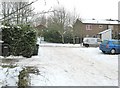
7
B5256, looking towards Leyland
This view is taken from the junction with Cam Wood Fold.
Image: © Ann Cook
Taken: 5 Jan 2010
0.12 miles

10

Sheep Hill Lane and the crossroads with Wood End Road
Today Sheep Hill Lane is blocked - - the bollards can be seen at the end of the lane. A larger road now by-passes this area.
Image: © Ann Cook
Taken: 4 Aug 2010
0.13 miles