IMAGES TAKEN NEAR TO
Brow Hey, PRESTON, PR5 8DS
Introduction
This page details the photographs taken nearby to Brow Hey, PR5 8DS by members of the Geograph project.
The Geograph project started in 2005 with the aim of publishing, organising and preserving representative images for every square kilometre of Great Britain, Ireland and the Isle of Man.

There are currently over 7.5m images from over14,400 individuals and you can help contribute to the project by visiting https://www.geograph.org.uk
Image Map (Loading...)


Getting Data...Please wait
Leaflet Map data © OpenStreetMap
Images are licensed for reuse under creativecommons.org/licenses/by-sa/2.0
Notes
- Clicking on the map will re-center to the selected point.
- The higher the marker number, the further away the image location is from the centre of the postcode.
Image Listing (10 Images Found)
Images are licensed for reuse under creativecommons.org/licenses/by-sa/2.0
Image
Details
Distance
2
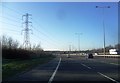
High Voltage Power Lines Cross the M65
Image: © Anthony Parkes
Taken: 14 Jan 2012
0.07 miles
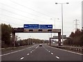
5
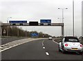
Junction 2 on the M65
The M61 runs from the M65.
Image: © Steve Daniels
Taken: 31 Oct 2017
0.16 miles
6
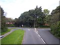
Clayton Brook Housing Estate
Great Greens Lane joins Clayton Brook Road
Image: © Raymond Knapman
Taken: 2 Aug 2012
0.17 miles
7
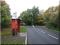
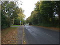
Bus stop and shelter on Great Greens Lane, Clayton Brook
Looking north west.
Image: © JThomas
Taken: 25 Oct 2018
0.18 miles
9
Canal terminus remains
This is looking towards all that remains of the terminus of the South branch of the Lancaster canal at Clayton Brook.
Image: © Paul Glenville
Taken: 24 Aug 2006
0.22 miles
10
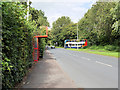
Traffic Calming Chicane on Clayton Brook Road
Image: © David Dixon
Taken: 9 Sep 2020
0.24 miles