IMAGES TAKEN NEAR TO
Brindle Road, PRESTON, PR5 6ZL
Introduction
This page details the photographs taken nearby to Brindle Road, PR5 6ZL by members of the Geograph project.
The Geograph project started in 2005 with the aim of publishing, organising and preserving representative images for every square kilometre of Great Britain, Ireland and the Isle of Man.

There are currently over 7.5m images from over14,400 individuals and you can help contribute to the project by visiting https://www.geograph.org.uk
Image Map
Images are licensed for reuse under creativecommons.org/licenses/by-sa/2.0
Notes
- Clicking on the map will re-center to the selected point.
- The higher the marker number, the further away the image location is from the centre of the postcode.
Image Listing (29 Images Found)
Images are licensed for reuse under creativecommons.org/licenses/by-sa/2.0
Image
Details
Distance
1
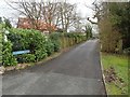
Bradkirk Lane
Bradkirk Lane is so named because it used to lead to Bradkirk Hospital which dealt with contagious diseases. Nowadays this part of the lane is a residential street and public bridleway.
This photo was taken from the junction with Brindle Road.
Image: © Adam C Snape
Taken: 21 Feb 2016
0.02 miles
2
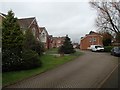
Modern housing on Cottage Gardens
The street is named Cottage Gardens because it was built on the site previously used by the former Cottage Garden Centre.
Image: © Adam C Snape
Taken: 21 Feb 2016
0.07 miles
3
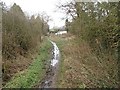
Looking along Bradkirk Lane
Bradkirk Lane is so named because it used to lead to Bradkirk Hospital which dealt with contagious diseases. This part of the lane is a public bridleway, though it becomes a residential street near the gate and white van in the distance.
Comparison with a similar earlier photo shows that the path surface has deteriorated in recent years. See Image
Image: © Adam C Snape
Taken: 21 Feb 2016
0.07 miles
5
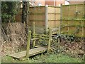
Footbridge and stile
A rather odd contraption to allow access to the residential street.
Image: © Adam C Snape
Taken: 21 Feb 2016
0.10 miles
6
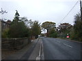
Brindle Road, Walton Summit Centre
Looking north west.
Image: © JThomas
Taken: 25 Oct 2018
0.11 miles
7
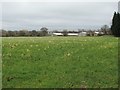
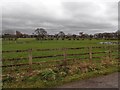
View across fields towards Grey Gables Farm
The buildings visible in the distance are Grey Gables Farm in Image
Image: © Adam C Snape
Taken: 21 Feb 2016
0.11 miles
8
Lions Den Railway Crossing, Bradkirk Lane
Bradkirk Lane is so named because it used to lead across the railway to Bradkirk Hospital which dealt with contagious diseases. The route remains a public bridleway up to the crossing. It is, however, a dead end for horses because the railway crossing is now just a foot crossing allowing access to Walton Summit Industrial Estate.
The crossing is known as Lions Den Crossing because there used to be a nearby farm called Lions Den.
Comparison with an earlier photo of the crossing (taken from the other side) shows that metal gates have replaced wooden ones in recent years. See Image
Image: © Adam C Snape
Taken: 21 Feb 2016
0.13 miles
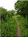
10
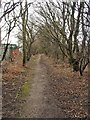
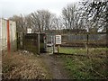
Footpath leading from railway crossing
Path connects Lions Den foot crossing http://www.geograph.org.uk/photo/4836883 with Walton Summit industrial estate.
Image: © Adam C Snape
Taken: 21 Feb 2016
0.15 miles