IMAGES TAKEN NEAR TO
Balshaw Street, PRESTON, PR5 6QN
Introduction
This page details the photographs taken nearby to Balshaw Street, PR5 6QN by members of the Geograph project.
The Geograph project started in 2005 with the aim of publishing, organising and preserving representative images for every square kilometre of Great Britain, Ireland and the Isle of Man.

There are currently over 7.5m images from over14,400 individuals and you can help contribute to the project by visiting https://www.geograph.org.uk
Image Map (Loading...)


Getting Data...Please wait
Leaflet Map data © OpenStreetMap
Images are licensed for reuse under creativecommons.org/licenses/by-sa/2.0
Notes
- Clicking on the map will re-center to the selected point.
- The higher the marker number, the further away the image location is from the centre of the postcode.
Image Listing (14 Images Found)
Images are licensed for reuse under creativecommons.org/licenses/by-sa/2.0
Image
Details
Distance
1
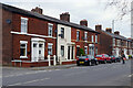
Station Road, Bamber Bridge
This line of terraced houses stands opposite St Aidan's Church in Bamber Bridge. Balshaw Street leads off to the left. Station Road is nowadays the B6258 but was previously a stretch of the A6.
Image: © Stephen McKay
Taken: 19 Apr 2023
0.03 miles
2
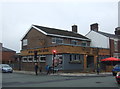
Walton Arms, Bamber Bridge
This pub, tucked away on St Aidan's Road, was formerly the School Lane Club and became a pub in 2015. The interior decor is in the very trendy 'steampunk' style.
Image: © Stephen McKay
Taken: 19 Apr 2023
0.12 miles
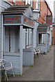
5
The Withy Arms, Bamber Bridge
On Station Road.
Image: © JThomas
Taken: 25 Oct 2018
0.18 miles
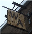
6
Cross Roads at Bamber Bridge
Brownedge Road crosses Station Road at the Withy Arms public house
Image: © Raymond Knapman
Taken: 2 Aug 2012
0.19 miles
7
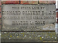
Walton Le Dale Local Board Offices (foundation stone)
The foundation stone on the corner of Image Although the date is badly worn and now almost unreadable, it is confirmed as 1880 on Image
Image: © David Dixon
Taken: 25 Feb 2012
0.19 miles
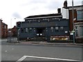
8
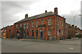
Former Council Offices, Bamber Bridge
The former offices of Walton Le Dale Local Board at the corner of Station Road and Brownedge Lane. The building is in two halves. The original part of the building, constructed in 1880, is nearest to the corner, whilst the later extension (in darker coloured bricks) is to the left.
See Image] and Image]
Image: © David Dixon
Taken: 25 Feb 2012
0.20 miles
9
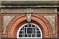
Walton Le Dale Local Board Offices (detail)
A close-up view of the detail over the doorway of Image
Image: © David Dixon
Taken: 25 Feb 2012
0.20 miles
10
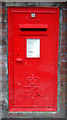
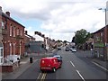
Elizabeth II postbox on Station Road, Bamber Bridge
Postbox No. PR5 50.
Image: © JThomas
Taken: 25 Oct 2018
0.21 miles