IMAGES TAKEN NEAR TO
Woodstock Close, PRESTON, PR5 5YY
Introduction
This page details the photographs taken nearby to Woodstock Close, PR5 5YY by members of the Geograph project.
The Geograph project started in 2005 with the aim of publishing, organising and preserving representative images for every square kilometre of Great Britain, Ireland and the Isle of Man.

There are currently over 7.5m images from over14,400 individuals and you can help contribute to the project by visiting https://www.geograph.org.uk
Image Map (Loading...)


Getting Data...Please wait
Leaflet Map data © OpenStreetMap
Images are licensed for reuse under creativecommons.org/licenses/by-sa/2.0
Notes
- Clicking on the map will re-center to the selected point.
- The higher the marker number, the further away the image location is from the centre of the postcode.
Image Listing (8 Images Found)
Images are licensed for reuse under creativecommons.org/licenses/by-sa/2.0
Image
Details
Distance
1
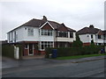
Houses on Brownedge Road, Lostock Hall (B5257)
Image: © JThomas
Taken: 25 Oct 2018
0.12 miles
2
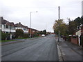
Brownedge Road, Lostock Hall (B5257)
Looking south west.
Image: © JThomas
Taken: 25 Oct 2018
0.13 miles
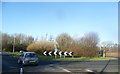
3
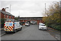
Brownedge Road
A road which has been cut by the rerouted A6 which runs over the bridge here.
Image: © Bill Boaden
Taken: 18 Nov 2017
0.17 miles
4
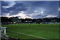
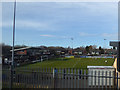
Football match at the Sir Tom Finney Stadium
A home match for Bamber Bridge FC.
Image: © Bill Boaden
Taken: 18 Nov 2017
0.19 miles
5
Bamber Bridge FC
Glimpsed playing Glossop.
Image: © Stephen Craven
Taken: 24 Mar 2018
0.19 miles

8
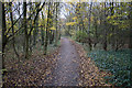
Woodland path to Preston
The path will very shortly join the Old Tramway cycle route to Preston Station.
Image: © Bill Boaden
Taken: 18 Nov 2017
0.24 miles