IMAGES TAKEN NEAR TO
North Grove, PRESTON, PR5 5UT
Introduction
This page details the photographs taken nearby to North Grove, PR5 5UT by members of the Geograph project.
The Geograph project started in 2005 with the aim of publishing, organising and preserving representative images for every square kilometre of Great Britain, Ireland and the Isle of Man.

There are currently over 7.5m images from over14,400 individuals and you can help contribute to the project by visiting https://www.geograph.org.uk
Image Map (Loading...)


Getting Data...Please wait
Leaflet Map data © OpenStreetMap
Images are licensed for reuse under creativecommons.org/licenses/by-sa/2.0
Notes
- Clicking on the map will re-center to the selected point.
- The higher the marker number, the further away the image location is from the centre of the postcode.
Image Listing (10 Images Found)
Images are licensed for reuse under creativecommons.org/licenses/by-sa/2.0
Image
Details
Distance
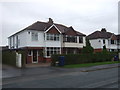
1
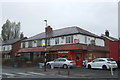
Off licence on Brownedge Road, Lostock Hall
Image: © JThomas
Taken: 25 Oct 2018
0.12 miles
2
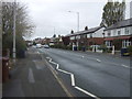
Brownedge Road, Lostock Hall
Looking west on the B5257.
Image: © JThomas
Taken: 25 Oct 2018
0.15 miles
3
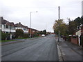
Brownedge Road, Lostock Hall (B5257)
Looking south west.
Image: © JThomas
Taken: 25 Oct 2018
0.19 miles
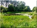
6
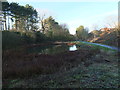
Site of the former Preston Junction
An attractive pond has formed in Preston Junction Nature Reserve on the site of the old railway junction, just south of Todd Lane and the former station.
The junction was at a point around the far end of the pond. The line to Bamber Bridge passed to the right. Its route is maintained as far as Brownedge Road as a shared use foot and cycle path (Route 55 of the National Cycle Network) which can be seen in the photo. The line to Lostock Hall passed to the left and may still be walked as far as Red Bridge on Brownedge Road.
A photo of the pond from a similar angle taken in summer can be seen here: Image
A photo of the pond taken from an alternative angle, looking from the former Lostock Hall branch of the junction can be seen here: Image
Image: © Adam C Snape
Taken: 27 Dec 2015
0.21 miles
7
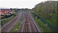
Railway junction near Lostock Hall Station
Viewed from Moss Bridge on Todd Lane South (formerly Moss Lane). Passenger journeys fork to the right here to reach Lostock Hall Station which lies just beyond the junction. There are no regular passenger services over the line forking left but it is used by freight and excursion trains.
Image: © Adam C Snape
Taken: 5 May 2016
0.21 miles
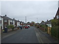
8
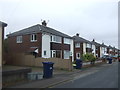
Houses on Brownedge Road, Lostock Hall (B5257)
Image: © JThomas
Taken: 25 Oct 2018
0.22 miles
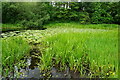
9
Pond Beside Cycle Route
Pond close to National Cycle Route 55 which looked rather pretty in today's sunshine.
Image: © Rude Health
Taken: 5 Jul 2013
0.24 miles
10
Turf zone KensingtnPond
Pond to the west of London Way near Bamber Bridge.
Image: © Ian S
Taken: 28 May 2023
0.24 miles