IMAGES TAKEN NEAR TO
Dovetree Close, PRESTON, PR5 4NN
Introduction
This page details the photographs taken nearby to Dovetree Close, PR5 4NN by members of the Geograph project.
The Geograph project started in 2005 with the aim of publishing, organising and preserving representative images for every square kilometre of Great Britain, Ireland and the Isle of Man.

There are currently over 7.5m images from over14,400 individuals and you can help contribute to the project by visiting https://www.geograph.org.uk
Image Map
Images are licensed for reuse under creativecommons.org/licenses/by-sa/2.0
Notes
- Clicking on the map will re-center to the selected point.
- The higher the marker number, the further away the image location is from the centre of the postcode.
Image Listing (16 Images Found)
Images are licensed for reuse under creativecommons.org/licenses/by-sa/2.0
Image
Details
Distance
1
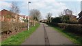
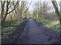
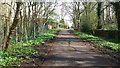
Old Tram Road
The Old Tram Road is now a path linking residential areas to Preston city centre and is also well used by people at leisure. At this point it passes through modern housing estates.
Image: © Paul Collins
Taken: 14 Apr 2018
0.05 miles
2
Old Tram Road Crossing Carrwood Way
The Old Tram Road is now a path linking residential areas to Preston city centre and is also well used by people at leisure. At this point it passes through modern housing estates.
Image: © Paul Collins
Taken: 14 Apr 2018
0.06 miles
3
Old Tram Road Approaching Carrwood Way
The Old Tram Road is now a path linking residential areas to Preston city centre and is also well used by people at leisure. At this point it passes through modern housing estates.
Image: © Paul Collins
Taken: 14 Apr 2018
0.08 miles
4
Old Tram Road
The Old Tram Road is now a path linking residential areas to Preston city centre and is also well used by people at leisure. At this point it passes through modern housing estates.
Image: © Paul Collins
Taken: 14 Apr 2018
0.12 miles
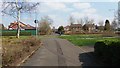
5
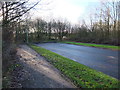
The end of Carrwood Road
Carrwood Road currently stops abruptly just before it meets the cycle path through Preston Junction Nature Reserve http://www.geograph.org.uk/snippet/14389 . There is a path to allow pedestrians and cyclists to access the nature reserve but the road goes no further.
Housing development on the old gasworks site to the west is dependent upon the construction of a new link road connecting Walton-le Dale and Penwortham by extending Carrwood Road to meet The Cawsey, a pre-existing estate road. It is proposed that the link road will pass over the nature reserve and cycle path by means of a bridge.
View from the cycle path: Image
More details about the development and link road: https://web.archive.org/web/20151229180207/http://www.leylandguardian.co.uk/news/local/former-gasworks-site-gets-the-go-ahead-for-280-new-homes-1-7411180
Image: © Adam C Snape
Taken: 27 Dec 2015
0.13 miles
6
Trees cleared for new link road bridge
An update of image ImageThe trees surrounding the old railway cycle route have now been cleared to allow for the construction of a bridge which will carry the new link road over it.
See also: Image
Image: © Adam C Snape
Taken: 12 May 2016
0.13 miles
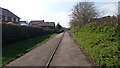
7
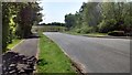
View along the cycle path towards the site of the proposed link road bridge
Housing development on the old gasworks site to the west is dependent upon the construction of a new link road connecting Walton-le Dale and Penwortham through the pre-existing estate roads Carrwood Road and The Cawsey. It is proposed that the link road will pass over this nature reserve and cycle path by means of a bridge at this point.
View from Carrwood Road: Image
More details about the development and link road: https://web.archive.org/web/20151229180207/http://www.leylandguardian.co.uk/news/local/former-gasworks-site-gets-the-go-ahead-for-280-new-homes-1-7411180
Image: © Adam C Snape
Taken: 27 Dec 2015
0.15 miles
8
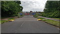
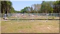
Cross borough link road under construction
The new bridge to link Carrwood Road and The Cawsey is built. Construction is now underway to link it to Carrwood Road.
Image: © Antony Walmsley
Taken: 26 May 2019
0.16 miles
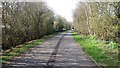
9
Old Tram Road
The Old Tram Road is now a path linking residential areas to Preston city centre and is also well used by people at leisure. The two horse-riders in the distance had taken a wrong turn and asked for directions - a first for me!
Image: © Paul Collins
Taken: 14 Apr 2018
0.17 miles
10
Site of the new bridge
Looking east towards Carrwood Road from the route of the new link road. It can be seen that the trees surrounding the old railway have been cleared pending the construction of the new bridge.
See also: Image
Image: © Adam C Snape
Taken: 12 May 2016
0.17 miles