IMAGES TAKEN NEAR TO
Cuerdale Lane, PRESTON, PR5 4EP
Introduction
This page details the photographs taken nearby to Cuerdale Lane, PR5 4EP by members of the Geograph project.
The Geograph project started in 2005 with the aim of publishing, organising and preserving representative images for every square kilometre of Great Britain, Ireland and the Isle of Man.

There are currently over 7.5m images from over14,400 individuals and you can help contribute to the project by visiting https://www.geograph.org.uk
Image Map
Images are licensed for reuse under creativecommons.org/licenses/by-sa/2.0
Notes
- Clicking on the map will re-center to the selected point.
- The higher the marker number, the further away the image location is from the centre of the postcode.
Image Listing (10 Images Found)
Images are licensed for reuse under creativecommons.org/licenses/by-sa/2.0
Image
Details
Distance
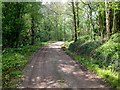
3
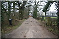
Track to Cuerdale Hall Farm
The signs make it clear that it is private property but there is a public footpath through the farm which is a kilometre ahead.
Image: © Bill Boaden
Taken: 4 Feb 2012
0.19 miles
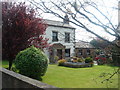
5
Woodhouse Farm barn
converted to a private residence.
Image: © Margaret Clough
Taken: 8 May 2006
0.20 miles
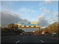
6
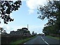
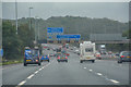
Bamber Bridge : M6 Motorway
The M6 Motorway between Junction 30 (Blacow Bridge) and Junction 31 (Ribble Valley Interchange).
Image: © Lewis Clarke
Taken: 23 Sep 2019
0.20 miles
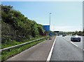
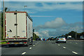
9
Cuerdale : M6 Motorway
The M6 Motorway between Junction 31 (Ribble Valley Interchange) and Junction 30 (Blacow Bridge).
Image: © Lewis Clarke
Taken: 27 Sep 2019
0.23 miles
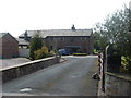
10
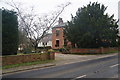
The entrance to Woodhouse Farm
This is now another residential enclave.
Image: © Bill Boaden
Taken: 4 Feb 2012
0.23 miles