IMAGES TAKEN NEAR TO
Church Terrace, PRESTON, PR5 4DL
Introduction
This page details the photographs taken nearby to Church Terrace, PR5 4DL by members of the Geograph project.
The Geograph project started in 2005 with the aim of publishing, organising and preserving representative images for every square kilometre of Great Britain, Ireland and the Isle of Man.

There are currently over 7.5m images from over14,400 individuals and you can help contribute to the project by visiting https://www.geograph.org.uk
Image Map (Loading...)


Getting Data...Please wait
Leaflet Map data © OpenStreetMap
Images are licensed for reuse under creativecommons.org/licenses/by-sa/2.0
Notes
- Clicking on the map will re-center to the selected point.
- The higher the marker number, the further away the image location is from the centre of the postcode.
Image Listing (35 Images Found)
Images are licensed for reuse under creativecommons.org/licenses/by-sa/2.0
Image
Details
Distance
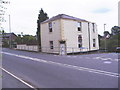
2
Wesleyan Chapel, Higher Walton, Preston
Chapel, built 1870 and now converted into two houses. The chapel replaced by the new church in Gregson Lane.
Image: © Alan Sillitoe
Taken: 28 Jun 2008
0.04 miles
4
All Saints Church, Higher Walton, Preston
Image: © Alan Sillitoe
Taken: 28 Jun 2008
0.04 miles
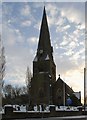
5
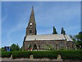
All Saints' Church, Higher Walton
The steeple of this rather magnificent church serves as a viewpoint for miles around.
Image: © Greum
Taken: 29 May 2023
0.04 miles
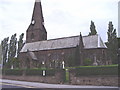
6
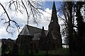
All Saints Church, Higher Walton
Church of England parish church.
Image: © philandju
Taken: 26 Apr 2013
0.04 miles
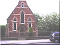
7
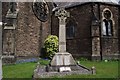
War memorial, Higher Walton
Within All Saints churchyard. Inscribed "In grateful memory 1914 - 1918".
Image: © philandju
Taken: 26 Apr 2013
0.04 miles
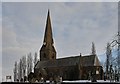
8

All Saints Church, Higher Walton
The church was built between 1861 and 1864 to a design by the Lancaster architect E. G. Paley at a cost of £6,000 (£440,000 as of 2013). It provided seating for 604 people. Paley donated a stained glass window depicting the healing of the sick man. The steeple was added in 1871 by the partnership of Paley and Austin. The church is designated by English Heritage as a Grade II listed building.
The churchyard contains the war graves of three soldiers of World War I, and an airman of World War II.
Image: © Rude Health
Taken: 24 Mar 2013
0.05 miles
9
Pineapple House, Higher Walton, Preston
House on the corner of Blackburn Road and Gregson Lane. This was originally a public house called the Pineapple. Above the door is a stone lintel with a pineapple cast.
Image: © Alan Sillitoe
Taken: 28 Jun 2008
0.06 miles
10
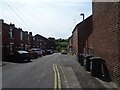
Brook Street, Higher Walton
A quick view along Brook Street.
Image: © Greum
Taken: 29 May 2023
0.09 miles