IMAGES TAKEN NEAR TO
Weasel Lane, PRESTON, PR5 0SB
Introduction
This page details the photographs taken nearby to Weasel Lane, PR5 0SB by members of the Geograph project.
The Geograph project started in 2005 with the aim of publishing, organising and preserving representative images for every square kilometre of Great Britain, Ireland and the Isle of Man.

There are currently over 7.5m images from over14,400 individuals and you can help contribute to the project by visiting https://www.geograph.org.uk
Image Map
Images are licensed for reuse under creativecommons.org/licenses/by-sa/2.0
Notes
- Clicking on the map will re-center to the selected point.
- The higher the marker number, the further away the image location is from the centre of the postcode.
Image Listing (7 Images Found)
Images are licensed for reuse under creativecommons.org/licenses/by-sa/2.0
Image
Details
Distance
1
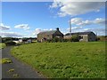
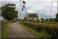
Highfield Farm
Highfield Farm above Hoghton Bottoms.
Image: © Greum
Taken: 2 Oct 2016
0.01 miles
2
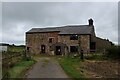
Highfields Farm
Look of abandonment permeates this farmhouse
Image: © Chris Heaton
Taken: 11 Sep 2021
0.02 miles
3
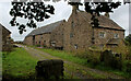
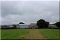
Bolton Hall Farm
Grade II Listed Building, with an air of neglect around the buildings.
Image: © Chris Heaton
Taken: 11 Sep 2021
0.15 miles
4
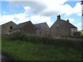
Bolton Hall
Bolton Hall is a rather magnificent set of archaic-looking buildings located on the heights west of the River Darwen between Hoghton Bottoms and Samlesbury Bottoms.
Image: © Greum
Taken: 4 Aug 2022
0.16 miles
5
Bolton Hall Farm
This is the example given to explain how to quote grid references on the 1:25000 OS sheet (287) for this area. Note how the (OS supplied) GR from the 1:25000 places the marker slightly north on the 1:50000 map here.
Image: © Mr T
Taken: 22 Sep 2007
0.17 miles
6
Approaching Bolton Hall Farm
Following the footpath from Samlesbury Bottoms and the Darwen Valley
Image: © Chris Heaton
Taken: 11 Sep 2021
0.18 miles
7
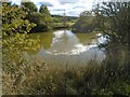
Pond at site of Tewit Hall
A pond in the north west of woodland surrounding the site of the now-ruined Tewit Hall.
Image: © Greum
Taken: 2 Oct 2016
0.19 miles