IMAGES TAKEN NEAR TO
Olive Farm Avenue, PRESTON, PR5 0AJ
Introduction
This page details the photographs taken nearby to Olive Farm Avenue, PR5 0AJ by members of the Geograph project.
The Geograph project started in 2005 with the aim of publishing, organising and preserving representative images for every square kilometre of Great Britain, Ireland and the Isle of Man.

There are currently over 7.5m images from over14,400 individuals and you can help contribute to the project by visiting https://www.geograph.org.uk
Image Map
Images are licensed for reuse under creativecommons.org/licenses/by-sa/2.0
Notes
- Clicking on the map will re-center to the selected point.
- The higher the marker number, the further away the image location is from the centre of the postcode.
Image Listing (18 Images Found)
Images are licensed for reuse under creativecommons.org/licenses/by-sa/2.0
Image
Details
Distance
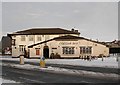
1
Trackway to Cuerdale Hey
This track leads from the top of Fox Lane in Coup Green towards Cuerdale Hey Farm (a.k.a. The Hey).
Image: © Greum
Taken: 20 Apr 2023
0.02 miles
2
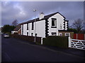
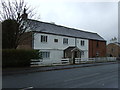
Cottages Coupe Green
Cottages built 1787
Image: © Alan Sillitoe
Taken: 5 Jan 2008
0.11 miles
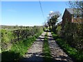
3
Passing a Building Site in Coup Green
The footpath keeps to the right of the hedge, only to come to an abrupt halt as it crosses a small footbridge a few yards further on. The building company has sealed off access without prior warning.
Option one is to turn around and walk back to Hoghton.
Option two is to be creative and find a channel to wriggle around all obstacles to bypass the site.
Option three, recommended for athletes and Marines only, vault over the 8ft high barrier and walk through construction workings without breaking stride.
Image: © Chris Heaton
Taken: 11 Sep 2021
0.15 miles
4
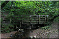
Footbridge over Beeston Brook
Not the most attractive brook, being sluggish with a fair amount of litter thrown in.
It carries the footpath between Coup Green and Fleetwood Hall over the brook in Beeston Wood.
Image: © Chris Heaton
Taken: 11 Sep 2021
0.15 miles
5
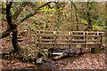
Beeston Brook
The bridge looked to be a fairly recent replacement.
Image: © Mr T
Taken: 17 Nov 2007
0.16 miles
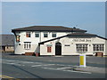
6
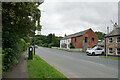
Hoghton Lane, Coupe Green
The A675 at the eastern end of the village, at its junction with Bells Lane.
Image: © Bill Boaden
Taken: 30 Aug 2021
0.18 miles
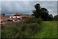
9
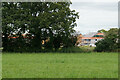
New housing on the edge of Coupe Green
The former field at the end of Manor Close is now being built on, as viewed from the next field.
Image: © Bill Boaden
Taken: 30 Aug 2021
0.20 miles