IMAGES TAKEN NEAR TO
Southport New Road, PRESTON, PR4 6HY
Introduction
This page details the photographs taken nearby to Southport New Road, PR4 6HY by members of the Geograph project.
The Geograph project started in 2005 with the aim of publishing, organising and preserving representative images for every square kilometre of Great Britain, Ireland and the Isle of Man.

There are currently over 7.5m images from over14,400 individuals and you can help contribute to the project by visiting https://www.geograph.org.uk
Image Map
Images are licensed for reuse under creativecommons.org/licenses/by-sa/2.0
Notes
- Clicking on the map will re-center to the selected point.
- The higher the marker number, the further away the image location is from the centre of the postcode.
Image Listing (7 Images Found)
Images are licensed for reuse under creativecommons.org/licenses/by-sa/2.0
Image
Details
Distance
1
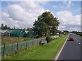
Garden centre on the A565 near Tarleton
Image: © Raymond Knapman
Taken: 8 Aug 2012
0.14 miles
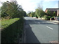
4
Blackgate Lane, Tarleton
The width of what is now a quiet country lane is evidence that this was at one time the main road from Tarleton towards Southport. The modern A565 is now used by through traffic.
Image: © K A
Taken: 10 Jul 2011
0.20 miles
6
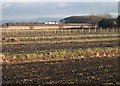
Where your Christmas sprouts were grown.
Sprouts being one of the crops grown in this intensely farmed area. The hill in the distance, looking east from Taylor's Lane is Winter Hill with its distinctive cluster of communication masts just about visible.
Image: © Chris Denny
Taken: 11 Jan 2011
0.21 miles
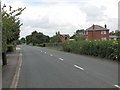
7
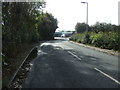
Blackgate Lane
Heading south towards Southport New Road.
Image: © JThomas
Taken: 11 Oct 2014
0.25 miles