IMAGES TAKEN NEAR TO
Ash Grove, PRESTON, PR4 2NY
Introduction
This page details the photographs taken nearby to Ash Grove, PR4 2NY by members of the Geograph project.
The Geograph project started in 2005 with the aim of publishing, organising and preserving representative images for every square kilometre of Great Britain, Ireland and the Isle of Man.

There are currently over 7.5m images from over14,400 individuals and you can help contribute to the project by visiting https://www.geograph.org.uk
Image Map
Images are licensed for reuse under creativecommons.org/licenses/by-sa/2.0
Notes
- Clicking on the map will re-center to the selected point.
- The higher the marker number, the further away the image location is from the centre of the postcode.
Image Listing (26 Images Found)
Images are licensed for reuse under creativecommons.org/licenses/by-sa/2.0
Image
Details
Distance
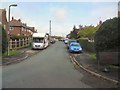
1
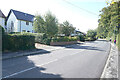
Ribby Road
The road is quiet because there are road works behind us that are completely blocking the road.
Image: © Malcolm Neal
Taken: 26 Sep 2021
0.20 miles
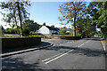
2
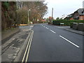
Ribby Road (B5259), Wrea Green
Heading east.
Image: © JThomas
Taken: 15 Nov 2014
0.21 miles
4
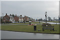
Wrea Green
Wrea Green is the village but it does have a very large village green the very edge of which you can see. The majority of it stretches away to the right beyond the second road in the middle distance.
Image: © Malcolm Neal
Taken: 4 Mar 2018
0.22 miles
6
Malcolm's Place
Malcolm's Place is a cul-de-sac of fairly modern houses between Ribby Hall and Wrea Green.
Image: © Malcolm Neal
Taken: 26 Sep 2021
0.22 miles
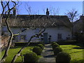
7
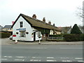
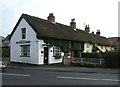
Church Row, Wrea Green
The near end cottage was once a bank
Image: © Alexander P Kapp
Taken: 31 Aug 2012
0.22 miles
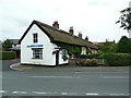
10
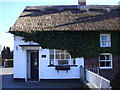
"The Old Bank" Church Row, Wrea Green, Lancashire
Image: © Robert Wade
Taken: 4 Mar 2010
0.23 miles