IMAGES TAKEN NEAR TO
Knitting Row Lane, PRESTON, PR3 6SX
Introduction
This page details the photographs taken nearby to Knitting Row Lane, PR3 6SX by members of the Geograph project.
The Geograph project started in 2005 with the aim of publishing, organising and preserving representative images for every square kilometre of Great Britain, Ireland and the Isle of Man.

There are currently over 7.5m images from over14,400 individuals and you can help contribute to the project by visiting https://www.geograph.org.uk
Image Map
Images are licensed for reuse under creativecommons.org/licenses/by-sa/2.0
Notes
- Clicking on the map will re-center to the selected point.
- The higher the marker number, the further away the image location is from the centre of the postcode.
Image Listing (14 Images Found)
Images are licensed for reuse under creativecommons.org/licenses/by-sa/2.0
Image
Details
Distance
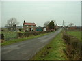
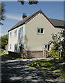
2
Footpath, Bridge and Stile off Knitting Row Lane
Image: © Bob Jenkins
Taken: 17 Mar 2009
0.13 miles
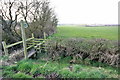
5
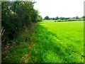
Grassland to the east of Kitting Row Lane
This grassland was accessed via a footpath from Kitting Row Lane however the footpath runs on the other side of the hedge.
Image: © Rude Health
Taken: 13 Aug 2015
0.16 miles
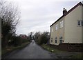
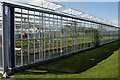
9
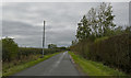
Cutts Lane looking West
The lake or ponds on the right are totally hidden by the hedge and there are only glimpses of the greenhouses.
Image: © Ian Greig
Taken: 3 Oct 2018
0.17 miles
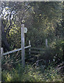
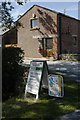
10

Knitting Row Trig Point
Easy bag from the west using footpath to south of Kitting Row Cottage then immediately through the first gate on the left to access fields with grazing cattle and an easy stroll to the trig.
Image: © Rude Health
Taken: 13 Aug 2015
0.18 miles