IMAGES TAKEN NEAR TO
Thorntrees Avenue, PRESTON, PR3 5DT
Introduction
This page details the photographs taken nearby to Thorntrees Avenue, PR3 5DT by members of the Geograph project.
The Geograph project started in 2005 with the aim of publishing, organising and preserving representative images for every square kilometre of Great Britain, Ireland and the Isle of Man.

There are currently over 7.5m images from over14,400 individuals and you can help contribute to the project by visiting https://www.geograph.org.uk
Image Map (Loading...)


Getting Data...Please wait
Leaflet Map data © OpenStreetMap
Images are licensed for reuse under creativecommons.org/licenses/by-sa/2.0
Notes
- Clicking on the map will re-center to the selected point.
- The higher the marker number, the further away the image location is from the centre of the postcode.
Image Listing (19 Images Found)
Images are licensed for reuse under creativecommons.org/licenses/by-sa/2.0
Image
Details
Distance
1
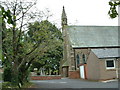
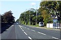
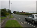
Garstang Road, Barton
The A6 at its junction with Station Lane.
Image: © philandju
Taken: 4 Sep 2013
0.05 miles
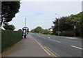
2
Station Lane, Barton
Heads west from the A6 in Barton, towards where the station once stood.
Image: © Chris Heaton
Taken: 31 Oct 2022
0.06 miles
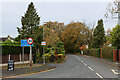
4

Playground at King George V Playing Field
Off Station Lane, Barton.
Image: © philandju
Taken: 4 Sep 2013
0.16 miles
5
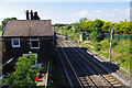
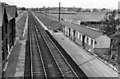
Barton & Broughton station
Looking north towards Lancaster from the road bridge.
See Ben Brooksbank's photo Image for a similar view in 1962.
The main station buildings on the down platform have been converted to housing, but the up platform and wooden buildings have gone.
The electrification of the west coast main line between Weaver Junction (near Crewe) and Glasgow was completed in 1974.
Image: © Ian Taylor
Taken: 22 Jun 2010
0.19 miles
7
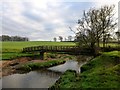
Footbridge Over Barton Brook
Walked from Barton into Black Fir Wood then into pasture before arriving at this footbridge across the Barton Brook. Barton Hall is hidden behind the tree.
Image: © Rude Health
Taken: 18 Dec 2012
0.19 miles
8
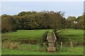
Footbridge over Barton Brook
Following a footpath westward to the village of Barton from the M6
Image: © Chris Heaton
Taken: 31 Oct 2022
0.19 miles
9
Barton & Broughton Station
View northward on West Coast Main Line, Preston - Lancaster section; station closed to passengers back on 1/5/39, to Goods on 31/5/65. (The station buildings were remarkably well-preserved after nearly 25 years!)
Image: © Ben Brooksbank
Taken: 10 Sep 1962
0.19 miles