IMAGES TAKEN NEAR TO
Riverside, PRESTON, PR3 3XS
Introduction
This page details the photographs taken nearby to Riverside, PR3 3XS by members of the Geograph project.
The Geograph project started in 2005 with the aim of publishing, organising and preserving representative images for every square kilometre of Great Britain, Ireland and the Isle of Man.

There are currently over 7.5m images from over14,400 individuals and you can help contribute to the project by visiting https://www.geograph.org.uk
Image Map
Images are licensed for reuse under creativecommons.org/licenses/by-sa/2.0
Notes
- Clicking on the map will re-center to the selected point.
- The higher the marker number, the further away the image location is from the centre of the postcode.
Image Listing (120 Images Found)
Images are licensed for reuse under creativecommons.org/licenses/by-sa/2.0
Image
Details
Distance
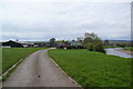
1
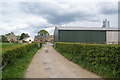
Farm on the edge of Ribchester
This is where the Ribble Way reaches Ribchester.
Image: © Bill Boaden
Taken: 5 May 2012
0.02 miles
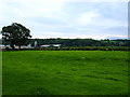
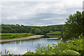
3
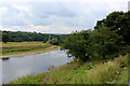
The River Ribble, Ribchester
The Ribble slightly downstream of the community of Ribchester
Image: © Chris Heaton
Taken: 18 Jul 2018
0.06 miles
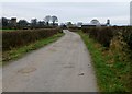
4
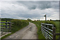
The Ribble Way bridleway goes straight ahead
There’s no trace on the ground of the footpath shown to the left by the fingerpost, or nearer to the river on the map
Image: © Ian Greig
Taken: 12 Jun 2012
0.07 miles
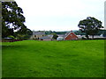
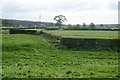
5
Farm on the southern edge of Ribchester
The River Ribble runs to the right. The tower of St Wilfrid's church is behind the farm buildings.
Image: © Bill Boaden
Taken: 5 May 2012
0.08 miles
7
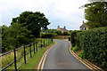
The Ribble Way heading out of Ribchester
The long distance footpath adopts Church Street as it heads out of Ribchester en route for the coast.
Image: © Chris Heaton
Taken: 18 Jul 2018
0.09 miles
8
Footpath leaving the churchyard at Ribchester
It crosses the rich farmland of the Ribble valley, heading towards Lower Barn Farm.
Image: © Bill Boaden
Taken: 5 May 2012
0.09 miles
10
The View Approaching Ribchester
This is the view approaching Ribchester on the Ribble Way with Saint Wilfrid's Church on the left and a dairy farm on the right.
Image: © Rude Health
Taken: 7 Jan 2013
0.09 miles