IMAGES TAKEN NEAR TO
Broomfield Road, PRESTON, PR3 3UL
Introduction
This page details the photographs taken nearby to Broomfield Road, PR3 3UL by members of the Geograph project.
The Geograph project started in 2005 with the aim of publishing, organising and preserving representative images for every square kilometre of Great Britain, Ireland and the Isle of Man.

There are currently over 7.5m images from over14,400 individuals and you can help contribute to the project by visiting https://www.geograph.org.uk
Image Map (20 Images)


Getting Data...Please wait
Leaflet Map data © OpenStreetMap
Images are licensed for reuse under creativecommons.org/licenses/by-sa/2.0
Notes
- Clicking on the map will re-center to the selected point.
- The higher the marker number, the further away the image location is from the centre of the postcode.
Image Listing (20 Images Found)
Images are licensed for reuse under creativecommons.org/licenses/by-sa/2.0
Image
Details
Distance
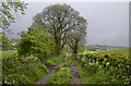
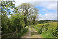
3
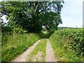
Green Bridleway Near Longridge
This bridleway is to the west of the Spade Mill Reservoir. It runs in a NNW direction from the B6243 road,
Image: © Rude Health
Taken: 8 Jul 2013
0.15 miles
8
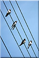
Swallows (Hirundo rustica), Longridge
A family party of two adults and two juveniles.
Image: © Mike Pennington
Taken: 28 Aug 1983
0.18 miles
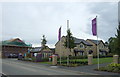
9
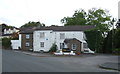
Thai Restaurant, Longridge
Former public house on Higher Road.
Image: © JThomas
Taken: 1 Oct 2016
0.19 miles