IMAGES TAKEN NEAR TO
Jeffrey Avenue, PRESTON, PR3 3TH
Introduction
This page details the photographs taken nearby to Jeffrey Avenue, PR3 3TH by members of the Geograph project.
The Geograph project started in 2005 with the aim of publishing, organising and preserving representative images for every square kilometre of Great Britain, Ireland and the Isle of Man.

There are currently over 7.5m images from over14,400 individuals and you can help contribute to the project by visiting https://www.geograph.org.uk
Image Map (Loading...)


Getting Data...Please wait
Leaflet Map data © OpenStreetMap
Images are licensed for reuse under creativecommons.org/licenses/by-sa/2.0
Notes
- Clicking on the map will re-center to the selected point.
- The higher the marker number, the further away the image location is from the centre of the postcode.
Image Listing (58 Images Found)
Images are licensed for reuse under creativecommons.org/licenses/by-sa/2.0
Image
Details
Distance
1
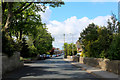
Higher Road, Longridge
Looking south west towards the town centre
Image: © Chris Heaton
Taken: 15 May 2020
0.07 miles
2
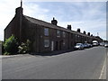
Club Row in Longridge
This terrace of 20 properties, erected between 1794 and 1804 is thought to be the oldest surviving example in the world of properties built by a building society. Each house had a basement room for a handloom, a coalhouse and a "Necessary". The 20 men who clubbed together to form the building society were: 9 yeomen, 4 handloom weavers, 2 stonemasons, 1 carpenter, 1 shopkeeper, 1 clogger, 1 travelling dealer and 1 cotton spinner.
(The source of this information is gratefully acknowledged to be the Longridge Heritage Committee.)
Image: © Phil and Juliette Platt
Taken: 28 Jun 2011
0.07 miles
3
Club Row, Higher Road, Longridge
This terrace was erected between 1794 and 1804. Thought to be the oldest surviving example of properties built by a building society in the world.
Image: © Alexander P Kapp
Taken: 15 Sep 2007
0.08 miles
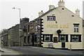
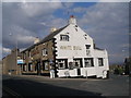
4
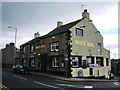
White Bull, Higher Road, Longridge
Image: © Alexander P Kapp
Taken: 15 Sep 2007
0.11 miles
6
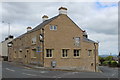
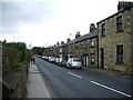
White Bull Mews, Longridge
Standing at the junction of Dilworth Lane and Higher Road in Longridge.
Former public house, that has now become residential accommodation.
Image: © Chris Heaton
Taken: 15 May 2020
0.13 miles
8

House on King Street, Longridge
Showing position of Postbox No. PR3 134.
See Image] for close up.
Image: © JThomas
Taken: 1 Oct 2016
0.13 miles
9

Elizabeth II postbox on King Street, Longridge
Postbox No. PR3 134.
See Image] for context.
Image: © JThomas
Taken: 1 Oct 2016
0.13 miles
10
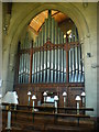
St Pauls Church, Longridge, Organ
Image: © Alexander P Kapp
Taken: 24 Jun 2009
0.14 miles