IMAGES TAKEN NEAR TO
Henry Littler Way, PR3 2JZ
Introduction
This page details the photographs taken nearby to Henry Littler Way, PR3 2JZ by members of the Geograph project.
The Geograph project started in 2005 with the aim of publishing, organising and preserving representative images for every square kilometre of Great Britain, Ireland and the Isle of Man.

There are currently over 7.5m images from over14,400 individuals and you can help contribute to the project by visiting https://www.geograph.org.uk
Image Map
Images are licensed for reuse under creativecommons.org/licenses/by-sa/2.0
Notes
- Clicking on the map will re-center to the selected point.
- The higher the marker number, the further away the image location is from the centre of the postcode.
Image Listing (17 Images Found)
Images are licensed for reuse under creativecommons.org/licenses/by-sa/2.0
Image
Details
Distance

2
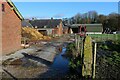
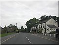
Whittingham Hall Farm
Farmyard at Whittingham Hall, next door to the now demolished psychiatric hospital near Goosnargh.
Image: © Chris Heaton
Taken: 19 Nov 2022
0.16 miles
3
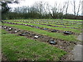
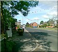
Old cemetery for Whittingham Hospital
Some of the patients here had long lives, one old boy reaching 112 years.
Image: © Peter Bond
Taken: 19 Mar 2011
0.16 miles
4
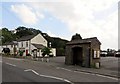
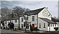
Pub and bus stop in Goosnargh
The Stag's Head.
Image: © philandju
Taken: 22 Aug 2013
0.16 miles
10
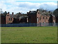
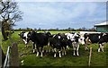
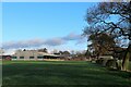
Cameron House, Whittingham Hospital
From the football pitch.
Image: © Peter Bond
Taken: 19 Mar 2011
0.18 miles