IMAGES TAKEN NEAR TO
Bleasdale Lane, PRESTON, PR3 1UQ
Introduction
This page details the photographs taken nearby to Bleasdale Lane, PR3 1UQ by members of the Geograph project.
The Geograph project started in 2005 with the aim of publishing, organising and preserving representative images for every square kilometre of Great Britain, Ireland and the Isle of Man.

There are currently over 7.5m images from over14,400 individuals and you can help contribute to the project by visiting https://www.geograph.org.uk
Image Map (Loading...)


Getting Data...Please wait
Leaflet Map data © OpenStreetMap
Images are licensed for reuse under creativecommons.org/licenses/by-sa/2.0
Notes
- Clicking on the map will re-center to the selected point.
- The higher the marker number, the further away the image location is from the centre of the postcode.
Image Listing (20 Images Found)
Images are licensed for reuse under creativecommons.org/licenses/by-sa/2.0
Image
Details
Distance

4
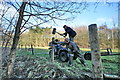
Big Hammer by River Brock
The field behind has an obvious route through it more so than but the public footpath which actually follows the river bank. The men are erecting a fence and gateways to guide the wandering public - including Geographers.
Image: © Bob Jenkins
Taken: 25 Feb 2009
0.15 miles
5
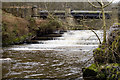
Weir and Thirlmere Aqueduct on River Brock
The
Image: © Tom Richardson
Taken: 20 Feb 2011
0.16 miles
7
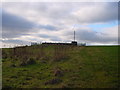
Water Thing
A Fylde Water Board relay station
Image: © Bob Jenkins
Taken: 25 Jan 2006
0.17 miles
8
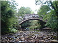
Brockmill Bridge
Road bridge over the Brock near Brockmill.
Image: © Chris Shaw
Taken: Unknown
0.17 miles
9
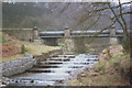
Thirlmere Aqueduct
The aqueduct that supplies Manchester, where it crosses the River Brock. Hence the name "Manchester Weir" on the map, presumably.
Image: © Stephen Craven
Taken: 7 Mar 1993
0.19 miles
10
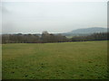
Farmland above the River Brock
The trees in the middle ground are in the Brock valley. Beacon Fell is the hill in the distance.
Image: © David Medcalf
Taken: 22 Jan 2006
0.20 miles